


Oceanography
1.1 Major Ocean Relief Features 4
Deep Sea Plain or Abyssal Plain 7
1.2 Minor Ocean Relief Features 7
Mid-Oceanic Ridges or Submarine Ridges 8
2.1 Oceans of the World by Size 12
Human Impact on marginal seas 24
Biomass Production and Primary Productivity 25
Water Circulation in Marginal Seas 26
2.6 Bays, gulfs, and Straits 27
Primary Forces Responsible for Ocean Currents 30
Secondary Forces Responsible for Ocean Currents 30
Desert Formation and Ocean Currents 44
Tidal Bulge: Why there are two tidal bulges? 45
4. Temperature Distribution of Oceans 55
4.1 Source of Heat in Oceans 55
4.2 Factors Affecting Temperature Distribution of Oceans 56
4.3 Vertical Temperature Distribution of Oceans 57
4.4 Horizontal Temperature Distribution 60
4.6 Range of Ocean Temperature 62
5.2 Factors Affecting Ocean Salinity 63
Horizontal distribution of salinity 63
5.3 Vertical Distribution of Salinity 66
6.1 Coral Reef Relief Features 66
Fringing Reefs (Shore Reefs) 67
6.2 Development of Major Coral Reef Types 69
6.3 Ideal Conditions for Coral Growth 70
Distribution of Coral Reefs 71
6.4 Corals and Zooxanthellae 71
Symbiotic Relationship Between Corals and Zooxanthellae 71
6.5 Coral Bleaching or Coral Reef Bleaching 72
Ecological Causes of Coral Bleaching 73
Spatial and temporal range of coral reef bleaching 75
7. Resources from the Ocean 75
Mineral deposits found on continental shelves and slopes 76
Mineral deposits found on deep sea floor 79
7.6 United Nations International Conferences on the Law of the Sea (UNCLOS) 85
Contiguous Zone or Pursuit Zone 87
Exclusive Economic Zone (EEZ) 87
Land Disputes in South China Sea: Parcel Islands and Spratly Islands 88
World Water Day – March 22
- Water on earth in liquid form came into existence in Hadean Eon (4,540 – 4,000 mya).
- During the Hadean Eon, temperature on earth was extremely hot, and much of the Earth was molten.
- Volcanic outgassing created the primordial atmosphere which consisted of various gases along with water vapour.
- Over time, the Earth cooled, causing the formation of a solid crust.
- The water vapour condensed to form rain and rainwater gradually filled the depressions on the newly solidified crust.
- The water in the depressions merged to give rise to mighty oceans.
- During the Hadean Eon, the atmospheric pressure was 27 times greater than it is today and hence even at a surface temperature of close to 200° C water remained liquid in the oceans.
- Over time, both temperature and atmospheric pressure dropped, and water continues to stay as liquid in the oceans.
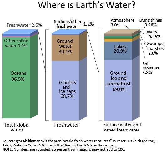
Water on the Earth’s surface
| Reservoir | Volume (Million Cubic km) | % of the Total |
| Oceans | 1,370 | 97.25 |
| Icecaps and Glaciers | 29 | 2.05 |
| Groundwater | 9.5 | 0.68 |
| Lakes | 0.125 | 0.01 |
| Soil Moisture | 0.065 | 0.005 |
| Atmosphere | 0.013 | 0.001 |
| Streams and Rivers | 0.0017 | 0.0001 |
| Biosphere | 0.0006 | 0.00004 |

Ocean Relief
- Ocean relief is largely due to tectonic, volcanic, erosional and depositional processes and their interactions.
- Ocean relief controls the motion of seawater.
- The oceanic movement in the form of currents, in turn, causes many variations in both oceans and atmosphere.
- The bottom relief of oceans also influences navigation and fishing.
Ocean relief features are divided into major and minor relief features:
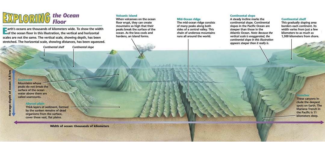

Ocean Relief Features
Major Ocean Relief Features
Four major divisions in the ocean relief are:
- the continental shelf,
- the continental slope,
- the continental rise,
- the Deep Sea Plain or the abyssal plain.
Continental Shelf
- Continental Shelf is the gently sloping (gradient of 1° or less) seaward extension of a continental plate.
- Continental Shelves cover 7.5% of the total area of the oceans.
- Shallow seas and gulfs are found along the continental shelves.
- The shelf typically ends at a very steep slope, called the shelf break.
- Examples of continental shelves: Continental Shelf of South-East Asia (Sunda Plate), Grand Banks around Newfoundland, Submerged region between Australia and New Guinea, etc.
Formation
- The shelf is formed mainly due to
- submergence of a part of a continent
- relative rise in sea level
- Sedimentary deposits brought down by rivers, glaciers
- There are various types of shelves based on different sediments of terrestrial origin —
- glaciated shelf (e.g. Shelf Surrounding Greenland),
- coral reef shelf (e.g. Queensland, Australia),
- shelf of a large river (e.g. Shelf around Nile Delta),
- shelf with dendritic valleys (e.g. shelf at the Mouth of Hudson River)
- shelf along young mountain ranges (e.g. Shelves between Hawaiian Islands).


Various types of shelves
Width and depth of continental shelves
- Continental shelves have an average width of 70-80 km.
- The shelves are almost absent or very narrow along a convergent boundary. E.g. coasts of Chile.
- The width of continental shelf of eastern coast of USA varies between 100-300 km.
- Siberian shelf in the Arctic Ocean is the largest in the world and stretches up to 1,500 km from the coast.


Width of various continental shelves
- Continental shelves may be as shallow as 30 m in some areas while in some areas it is as deep as 600 m.
Importance of continental shelves
- 20% of the world production of petroleum and gas comes from shelves.
- Continental shelves form the richest fishing grounds. E.g. Grand Banks around Newfoundland.
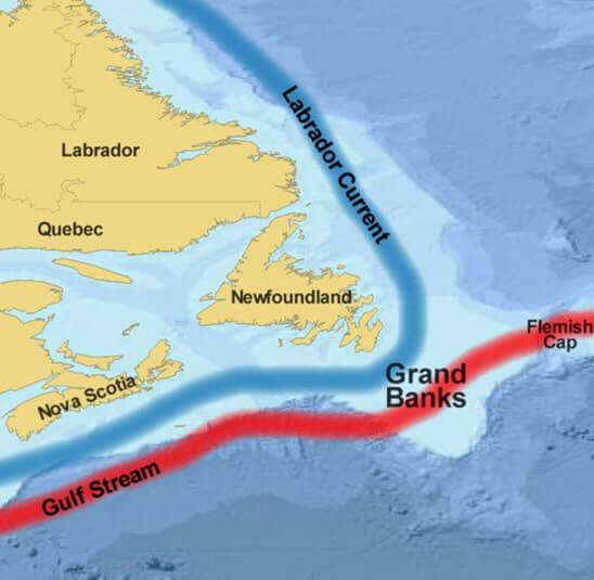

Grand Banks, the richest fishing grounds on earth
- Marine food comes almost entirely from continental shelves.
- They are sites for placer deposits and phosphorites (explained in Ocean Resources).
Continental Slope
- The gradient of the slope region varies between 2-5°.
- The continental slope connects the continental shelf and the ocean basins.
- The depth of the slope region varies between 200 and 3,000 m.
- The seaward edge of the continental slope loses gradient at this depth and gives rise to continental rise.
- The continental slope boundary indicates the end of the continents.
- Canyons and trenches are observed in this region.
Continental Rise
- The continental slope gradually loses its steepness with depth.
- When the slope reaches a level of between 0.5° and 1°, it is referred to as the continental rise.
- With increasing depth, the rise becomes virtually flat and merges with the abyssal plain.


Shelf, Slope and Rise (Wikipedia)
Deep Sea Plain or Abyssal Plain
- Deep sea planes are gently sloping areas of the ocean basins.
- These are the flattest and smoothest regions of the world because of terrigenous (marine sediment eroded from the land) and shallow water sediments that buries the irregular topography.
- It covers nearly 40% of the ocean floor.
- The depths vary between 3,000 and 6,000 m.
- These plains are covered with fine-grained sediments like clay and silt.
Minor Ocean Relief Features
- Ridges (along a divergent boundary),
- Abyssal Hills (submerged volcanic mountains): Seamounts and Guyots,
- Trenches (along a convergent boundary),
- Canyons (erosional landform),
- Island arcs (formed due to volcanism along a convergent boundary or hotspot volcanism),
- Atolls and Coral reefs.
Oceanic Deeps or Trenches
- The trenches are relatively steep-sided, narrow basins (Depressions).
- These areas are the deepest parts of the oceans.
- They are of tectonic origin and are formed during ocean-ocean convergence and ocean-continent convergence.
- They are some 3-5 km deeper than the surrounding ocean floor.
- The trenches lie along the fringes of the deep-sea plain at the bases of continental slopes and along island arcs.
- The trenches run parallel to the bordering fold mountains or the island chains.
- The trenches are very common in the Pacific Ocean and form an almost continuous ring along the western and eastern margins of the Pacific.
- The Mariana Trench off the Guam Islands in the Pacific Ocean is the deepest trench with, a depth of more than 11 kilometres.
- Trenches are associated with active volcanoes and strong earthquakes (like in Japan).
- Majority of the trenches are in the Pacific Ocean followed by the Atlantic Ocean and Indian Ocean.
Mid-Oceanic Ridges or Submarine Ridges
- A mid-oceanic ridge is composed of two chains of mountains separated by a large depression (divergent boundary).
- The mountain ranges can have peaks as high as 2,500 m and some even reach above the ocean’s surface.
- Running for a total length of 75,000 km, these ridges form the largest mountain systems on earth.

Mid Ocean Ridge
- The ridges are either broad, like a plateau, gently sloping or in the form of steep-sided narrow mountains.
Abyssal Hills


Abyssal Hills
- Seamount: It is a mountain with pointed summits, rising from the seafloor that does not reach the surface of the ocean. Seamounts are volcanic in origin. These can be 3,000-4,500 m tall.
- The Emperor seamount, an extension of the Hawaiian Islands in the Pacific Ocean, is a good example.
- Guyots: The flat-topped mountains (seamounts) are known as guyots.
- Seamounts and guyots are very common in the Pacific Ocean.
Submarine Canyons
Canyon: a deep gorge, especially one with a river flowing through it.
Gorge: a steep, narrow valley or ravine.
Valley: a low area between hills or mountains typically with a river or stream flowing through it.


Canyon, George, Valley
- Submarine canyons are deep valleys often extending from the mouths of the rivers to the abyssal plains.
- They are formed due to erosion by sediments brought down by rivers that cut across continental shelves, slopes and rises. The sediments are deposited on the abyssal plains.
- Submarine canyons can be far higher in scale compared to those that occur on land.

Submarine Canyon
Broadly, there are three types of submarine canyons:
- Small gorges which begin at the edge of the continental shelf and extend down the slope to very great depths, e.g., Oceanographer Canyons near New England.
- Those which begin at the mouth of a river and extend over the shelf, such as the Indus canyons.
- Those which have a dendritic appearance and are deeply cut into the edge of the shelf and the slope, like the canyons off the coast of southern California.
- The Hudson Canyon is the best-known canyon in the world.
- The largest canyons in the world occur in the Bering Sea off Alaska.
Atoll
- These are low islands found in the tropical oceans consisting of coral reefs surrounding a central depression.
- It may be a part of the sea (lagoon), or sometimes form enclosing a body of fresh, brackish, or highly saline water.
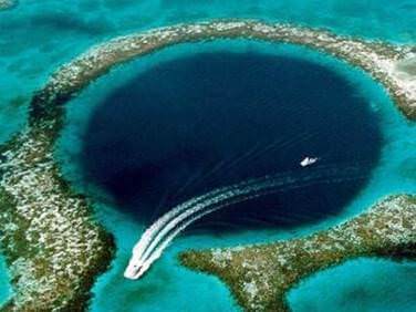

Atoll
Bank, Shoal and Reef
- These marine features are formed as a result of erosional, depositional and biological activity.
- These are produced upon features of diastrophic (earth movements) origin. Therefore, they are located on upper parts of elevations.
Bank
- These marine features are formed as a result of erosional and depositional activity.
- A bank is a flat-topped elevation located in the continental margins.
- The depth of water here is shallow but enough for navigational purposes.
- The Dogger Bank in the North Sea and Grand Bank in the north-western Atlantic, Newfoundland are examples.
- The banks are sites of some of the most productive fisheries of the world.
Shoal
- A shoal is a detached elevation with shallow depths.
- Since they project out of water with moderate heights, they are dangerous for navigation.


Shoal
Reef
- A reef is a predominantly organic deposit made by living or dead organisms that forms a mound or rocky elevation like a ridge.
- Coral reefs are a characteristic feature of the Pacific Ocean where they are associated with seamounts and guyots.
- The largest reef in the world is found off the Queensland coast of Australia.
- Since the reefs may extend above the surface, they are generally dangerous for navigation.
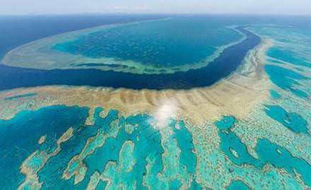

Reef
Major Oceans and Seas
Oceans of the World by Size
| Rank | Ocean | Area (million km2) (%) | Average Depth (m) |
| 1 | Pacific Ocean | 168 (46.6%) | 3,970 |
| 2 | Atlantic Ocean | 85 (23.5%) | 3,646 |
| 3 | Indian Ocean | 70 (19.5%) | 3,741 |
| 4 | Antarctic Ocean | 21 (6.1%) | 3,270 |
| 5 | Arctic Ocean | 15 (4.3%) | 1,205 |
- Total surface area of earth: 510 million km2
- Total water surface area: 70.8% (361 million km2)
- Total land surface area: 29.2% (149 million km2)
The Pacific Ocean
- Largest and deepest ocean.
- Covers about one-third of the earth’s surface.
- Average depth is generally around 7,300 metres.
- Its shape is roughly triangular with its apex in the north at the Bering Strait.
- Many marginal seas, bays and gulfs occur along its boundaries.
- Nearly 20,000 islands dot this vast ocean.
North and Central Pacific
- Characterized by maximum depth and a large number of deeps, trenches and islands.
- Some well-known trenches are Aleutian and Kuril.
- There are also a large number of seamounts and guyots (E.g. Hawaiian Hotspot).
West and South-West Pacific
- Average depth is about 4,000 m.
- It is marked by a variety of islands, marginal seas, continental shelves and submarine trenches.
- Mariana Trench and Mindanao Trench are very deep with a depth of more than 10,000 metres.
South-East Pacific
- This part is conspicuous for the absence of marginal seas and has submarine ridges and plateaus.
- The Tonga and Atacama trenches are prominent.


Pacific Ocean Topography (Exaggerated) showing trenches and spreading sites
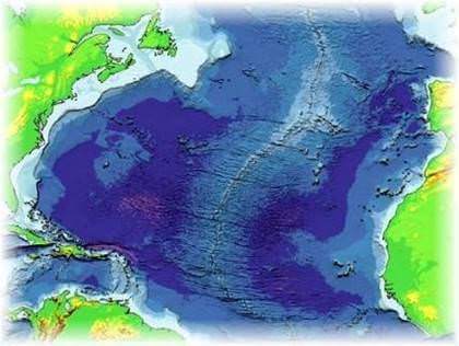
The Atlantic Ocean
- The Atlantic is the second largest ocean after the Pacific.
- It is roughly half the size of the Pacific Ocean.
- Its shape resembles the letter ‘S’.
- In terms of trade, it is the most significant of all oceans.
Continental Shelf
- It has prominent continental shelf with varying widths.
- The length of the continental shelf is maximum in Northern Atlantic coasts.
- The largest width occurring off north-east America and north-west Europe.
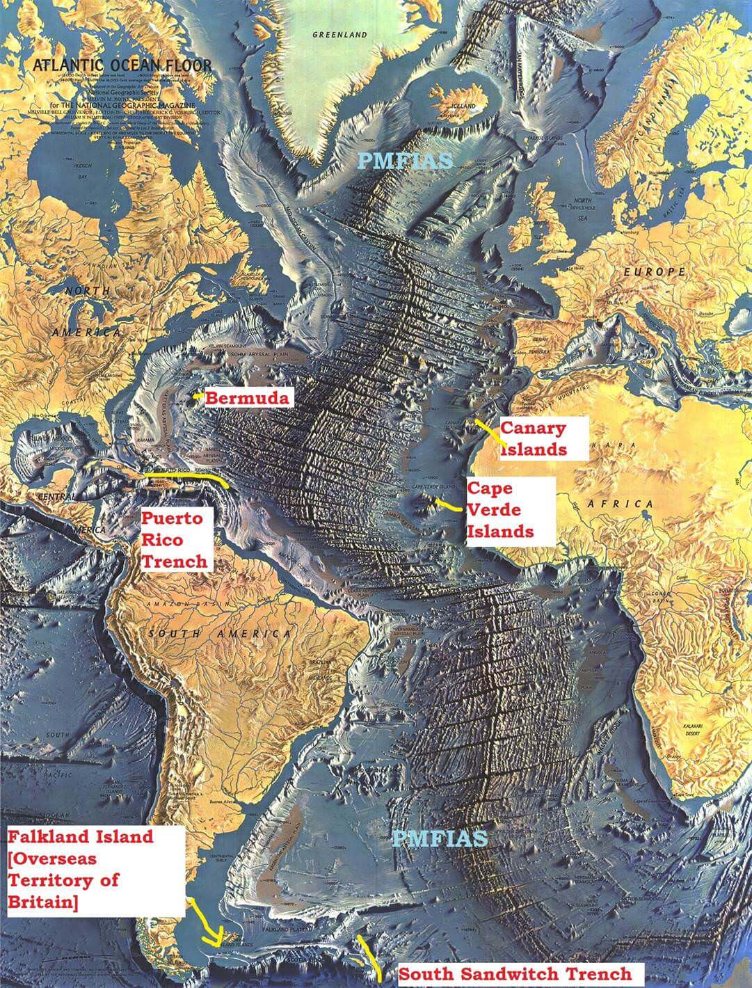

Atlantic Ocean Topography (Exaggerated) showing trenches and spreading sites
- Grand banks continental shelf is the most productive continental shelf in the world.
- The Atlantic Ocean has numerous marginal seas occurring on the shelves, like the Hudson Bay, the Baltic Sea, and the North Sea, and beyond the shelves like the Gulf of Florida (Mexican Gulf).
Mid-Atlantic Ridge
- The most remarkable feature of the Atlantic Ocean is the Mid-Atlantic Ridge which runs from north to the south paralleling the ‘S’ shape of the ocean.
- The ridge has an average height of 4 km and is about 14,000 km long.
Seamounts and guyots
- They are present in significant numbers but not as significant as in Pacific Ocean.
- Several seamounts form islands of the mid-Atlantic. Examples include Pico Island of Azores, Cape Verde Islands, Canary Islands etc.
- Also, there are coral islands like Bermuda and volcanic islands like St Helena etc.
Trenches
- Atlantic Ocean lacks significant troughs and trenches, which are most characteristic to the Pacific Ocean.
- North Cayman and Puerto Rico are the two troughs and Romanche and South Sandwich are the two trenches in the Atlantic Ocean.
The Indian Ocean
- Indian Ocean is the third largest of the world’s oceanic divisions.
- Smaller and less deep than the Atlantic Ocean.
Submarine ridges
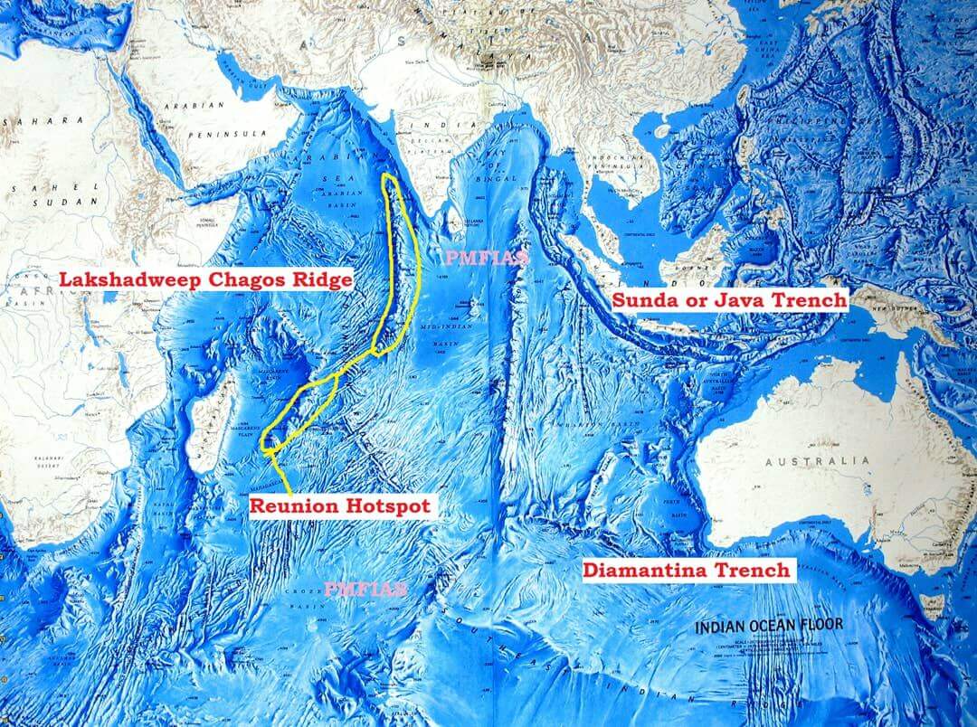
- Submarine ridges in this ocean include the Lakshadweep-Chagos Ridge (Reunion Hotspot Volcanism), the Socotra-Chagos Ridge, the Seychelles Ridge, the South Madagascar Ridge, Carlsberg Ridge etc..
- These ridges divide the ocean bottom into many basins. Chief among these are the Central Basin, Arabian Basin, South Indian Basin, Mascarene Basin, West Australian and South Australian Basins.


Indian Ocean Topography (Exaggerated) showing trenches and spreading sites
Islands
- Most of the islands in the Indian Ocean are continental islands and are present in the north and west.
- These include the Andaman and Nicobar, Sri Lanka, Madagascar and Zanzibar.
- The Lakshadweep and Maldives are coral islands and Mauritius and the Reunion Islands are of volcanic origin.
Continental Shelf
- The ocean’s continental shelves are narrow, averaging 200 kilometres (120 mi) in width.
- An exception is found off Australia’s northern coast, where the shelf width exceeds 1,000 kilometres (620 mi).
- The average depth of the ocean is 3,890 m (12,762 ft).
Trenches
- Linear deeps are almost absent. Few exceptions are Sunda Trench, which lies to the south of the island of Java and Diamantina Trench, west of Australia.
- Its deepest point is Diamantina Deep in Diamantina Trench, at 8,047 m. Sunda Trench off the coast of Java is also considerably deep.
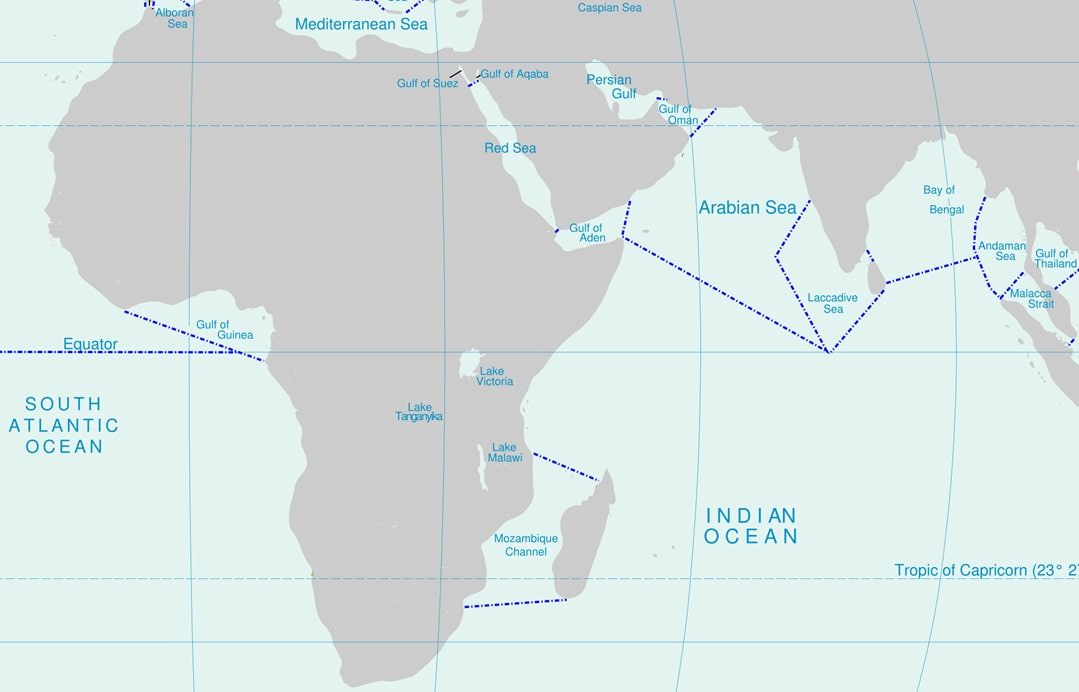
Straits
- Most of the straits in Indian Ocean are important trade roots.
- The major chokepoints include Bab el Mandeb (between Yemen and Djibouti, Eritrea), Strait of Hormuz (separates Persian Gulf from the Gulf of Oman), the Lombok Strait (connects Java Sea to the Indian Ocean), the Strait of Malacca (between Malay peninsula and Sumatra Island) and the Palk Strait.
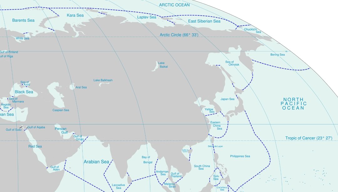
Marginal Seas
- In oceanography, a marginal sea is a sea partially enclosed by islands, archipelagos, or peninsulas.
- Some of the major marginal seas include the Arabian Sea, Baltic Sea, Bay of Bengal, Bering Sea, Black Sea, Gulf of California, Gulf of Mexico, Mediterranean Sea, Red Sea, and all four of the Siberian Seas (Barents, Kara, Laptev, and East Siberian).
- The primary differences between marginal seas and open oceans are associated with depth and proximity to landmasses.
- Marginal seas, which are generally shallower than open oceans, are more influenced by human activities, river runoff, climate, and water circulation.
Marginal Seas map: https://drive.google.com/file/d/0B1myJlOn-mMCNWJYSWtMZTItVGM/view?usp=sharing


Major Marginal Seas
Human Impact on marginal seas
- Marginal seas are more susceptible to pollution than open ocean regions.
- The greatest human impact on marginal seas is related to the fisheries industry.
- 90% of the world’s fisheries exist within coastal waters that are located less than 200 km from the shoreline.
- Other human activities that have adversely affected marginal seas include industrial sewage disposal, offshore oil drilling, accidental releases of pollutants, radioactive waste, etc.
- Pollutants from the nearby landmasses are introduced into marginal seas in concentrations that are thousands of times greater than in open oceans.
Phytoplankton Bloom (Algal Bloom) in Marginal Seas
- The Mediterranean Sea and the Black Sea are marginal seas found in proximity to one another. The colors difference is due to a phytoplankton bloom occurring in the Black Sea.
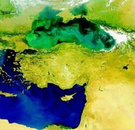

Phytoplankton bloom in the Black Sea
- Phytoplankton are good as fish feed on them. But when they proliferate indiscriminately, they consume too much oxygen during nights, thus depriving other marine organisms of oxygen.
- For example, the discharge of domestic sewage leads to elevated nutrient concentrations (particularly phosphates) which can result in harmful algal blooms.
Biomass Production and Primary Productivity
- Marine biomass production originates with primary productivity, which in turn is affected by the availability of sunlight, carbon dioxide, nutrients such as nitrates and phosphates, and trace elements.
- Marginal seas generally exhibit intermediate levels of primary production, with the highest rates found in coastal upwelling regions and the lowest primary production occurring in open ocean regions.
- For nearshore regions, the dominant processes influencing primary productivity are river runoff, water column mixing, and turbidity.
- River runoff and water column mixing introduce dissolved nutrients and trace elements into the photic (light) zones of nearshore regions.
- Although the addition of dissolved nutrients and trace elements serve to increase primary production, the addition of suspended particles increases water turbidity, which results in reduced sunlight penetration and decreased primary productivity.
Water Circulation in Marginal Seas
- Water circulation patterns in marginal seas depend largely on shape of the sea, fresh-water input (e.g., river runoff and precipitation) and evaporation.
- If river runoff and precipitation exceed evaporation, as is the case in the Black and Baltic Seas, the excess fresh water will tend to flow seaward near the sea surface.
- If evaporation exceeds river runoff and precipitation, as in the Mediterranean Sea, the marginal sea water becomes saltier, then sinks and flows towards the less salty open ocean region.
Circulation Patterns in Major Marginal Seas:
Black Sea and Baltic Sea
- The Black Sea and Baltic Sea basins both possess sills that restrict subsurface water circulation.
- While the surface waters of the Black and Baltic Seas are able to flow over the sills and introduce lower salinity water into the open ocean, the flow of the saltier subsurface waters is blocked by these sills.
- This type of subsurface-water restriction often leads to stagnation, which may eventually result in local oxygen depletion.
Mediterranean Sea
- The Mediterranean Sea, which is divided by a 400-meter sill into two sub-basins, is connected to the Atlantic Ocean via the Straits of Gibraltar, to the Black Sea via the Bosporus Strait, and to the Red Sea via the humanmade Suez Canal.
- Atlantic Ocean water enters this marginal sea through the Straits of Gibraltar as a surface flow. This ocean water replaces a fraction of the water that evaporates in the eastern Mediterranean Sea.
- In Mediterranean Sea evaporation exceeds precipitation and hence salinity increases.
Gulf of Mexico
- The Gulf of Mexico is connected to the Atlantic Ocean via the Straits of Florida and the Caribbean Sea via the Yucatán Strait.
- In the northern Gulf of Mexico region, Mississippi River runoff influences surface waters as far as 150 meters away from the shore, resulting in salinities as low as 25.
- A unique feature of the Gulf of Mexico’s surface circulation pattern is the Loop Current, which results from the Caribbean Current entering the Gulf of Mexico through the Yucatán Strait and upon arrival, turning in a clockwise direction and “looping” around a warm “dome” of Gulf of Mexico surface water.
Bays, gulfs, and Straits
- Bays, gulfs, and straits are types of water bodies that are contained within a larger body of water near land.
- These three water bodies are usually located at important points of human activities; thus, conflicts with nature and neighbours are common.
Bays
- A bay is a small body of water that is set off from a larger body of water generally where the land curves inward.
- In simple words, bay is a water body surrounded on three sides by land with the fourth side (mouth) wide open towards oceans. (In Gulfs, the mouth is narrow).
- A bay is usually smaller and less enclosed than a gulf.
- Example: The Bay of Pigs (Cuba), Hudson Bay (Canada), Bay of Bengal etc.
- An example of a bay at a river’s mouth is New York Bay, at the mouth of the Hudson River (Hudson Estuary).
Guantánamo Bay
|
Gulfs
- A gulf is a large body of water, sometimes with a narrow mouth, that is almost completely surrounded by land. The world’s largest gulf is the Gulf of Mexico.
- Examples of other gulfs include the Gulf of California, Gulf of Aden (between the Red Sea and the Arabian Sea), and the Persian Gulf (between Saudi Arabia and Iran).
- The Persian Gulf is important with respect to world energy because petroleum is transported through its waters in oil tankers.
Straits
- A strait is a narrow passageway of water, usually between continents or islands, or between two larger bodies of water.
- The Strait of Gibraltar is probably the world’s most famous strait. It connects the Atlantic Ocean on its west with the Mediterranean Sea on its east.
- Two other well-known straits are the Strait of Bosporus and the Strait of Hormuz.
- The Strait of Bosporus connects the Black Sea (from the north) and the Sea of Marmara (from the south) and splits north-western Turkey.
- The Strait of Hormuz is located at the south-eastern end of the Persian Gulf. It is a narrow waterway that can be (and has been) controlled to prevent ships from sailing through the gulf.
Choke Point
- When a body of water such as a strait is capable of being blocked or even closed in order to control transportation routes, the body is called a “choke point.”
- Historically, the Strait of Gibraltar has been one of the world’s most important choke points.
- However, the Strait of Hormuz has become an important choke point in recent years because of increasing Middle East tensions.
- The Strait is surrounded by the United Arab Emirates and Oman (on one side) and Iran (on the other side).
Isthmus
- Isthmus is the land-equivalent of a strait. i.e., a narrow strip of land connecting two larger land masses.
- Example: Isthmus of Panama and Isthmus of Suez.
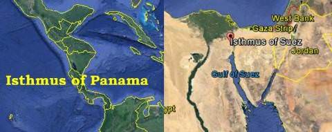

Isthmus of Panama and Isthmus of Suez
Ocean Movements
- The movements that occur in oceans are categorized as waves, tides and currents.
- Waves are formed due to friction between wind and surface water layer. The stronger the wind, the bigger the wave. They die out quickly on reaching the shore or shallow waters.
- Horizontal currents arise mainly due to friction between wind and water.
- Coriolis force and differences in water level gradient also play a major role.
- Vertical currents arise mainly due to density differences caused by temperature and salinity changes.
- Tsunami, storm surge and tides are tidal waves (meaning waves with large wavelengths).
Ocean Currents
- Ocean currents are the most important ocean movements because of their influence on climatology of various regions.
- Ocean currents are like river flow in oceans. They represent a regular volume of water in a definite path and direction.
- Ocean currents are influenced by two types of forces namely:
- primary forces that initiate the movement of water;
- secondary forces that influence the currents to flow.
- The primary forces that influence the currents are:
- heating by solar energy;
- wind;
- gravity;
- Coriolis force.
- The secondary forces that influence the currents are:
- Temperature difference;
- Salinity difference
Primary Forces Responsible for Ocean Currents
Explain the factors responsible for the origin of ocean currents. How do they influence regional climates, fishing and navigation? (Mains 2015)
Influence of insolation
- Heating by solar energy causes the water to expand.
- Near the equator, the ocean water is about 8 cm higher in level than in the middle latitudes.
- Gravity tends to level the differences by pulling the water down the pile (along the gradient).
Influence of wind (atmospheric circulation)
- Frictional force of the wind drags the surface ocean water.
- Winds are responsible for both magnitude and direction (Coriolis force) of the ocean currents.
- Example: Monsoon winds are responsible for the seasonal reversal of ocean currents in the Indian ocean.
- The oceanic circulation pattern roughly corresponds to the earth’s atmospheric circulation pattern.
- The air circulation over the oceans in the middle latitudes is mainly anticyclonic (sub-tropical High-Pressure Belt) The oceanic circulation pattern also corresponds with the same.
- At higher latitudes, where the wind flow is mostly cyclonic, the oceanic circulation follows this pattern.
Influence of Coriolis force
- The Coriolis force intervenes and causes the water to move to the right in the northern hemisphere and to the left in the southern hemisphere.
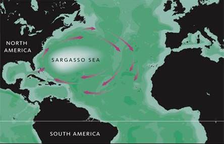
- These large accumulations of water and the flow around them are called Gyres. These produce large circular currents in all the ocean basins. One such circular current is the Sargasso Sea.
Secondary Forces Responsible for Ocean Currents
- Temperature difference and salinity difference are the secondary forces. They create density differences.
- Differences in water density affect vertical mobility of ocean currents (vertical currents).
- Water with high salinity is denser than water with low salinity.
- Similarly, cold water is denser than warm water.
- Denser water tends to sink, while relatively lighter water tends to rise.
Types of Ocean Currents
Based on depth the ocean currents may be classified based on their depth as surface currents and deep water currents:
- Surface currents constitute about 10 per cent of all the water in the ocean; these waters are the upper 400 m of the ocean.
- Deep water currents make up the other 90 per cent of the ocean water. These waters move around the ocean basins due to variations in the density and gravity.
- For instance, heavy surface water (due to increase in salinity) of the Mediterranean Sea sinks and flows westward past Gibraltar as a sub-surface current.
Based on temperature ocean currents are classified as cold currents and warm currents.
- Cold-water ocean currents occur when the cold water at the poles sinks and slowly moves towards the equator as subsurface flow.
- Warm-water currents travel out from the equator along the surface, flowing towards the poles to replace the sinking cold water.
- Cold currents are usually found on the west coast of the continents (because of clockwise flow in northern hemisphere and anti-clockwise flow in southern hemisphere) in the low and middle latitudes (true in both hemispheres) and on the east coast in the higher latitudes in the Northern Hemisphere.
- Warm currents are usually observed on the east coast of continents in the low and middle latitudes (true in both hemispheres). In the northern hemisphere, they are found on the west coasts of continents in high latitudes.
Convergence: warm and cold currents meet.
Divergence: a single current splits into multiple currents flowing in different directions.
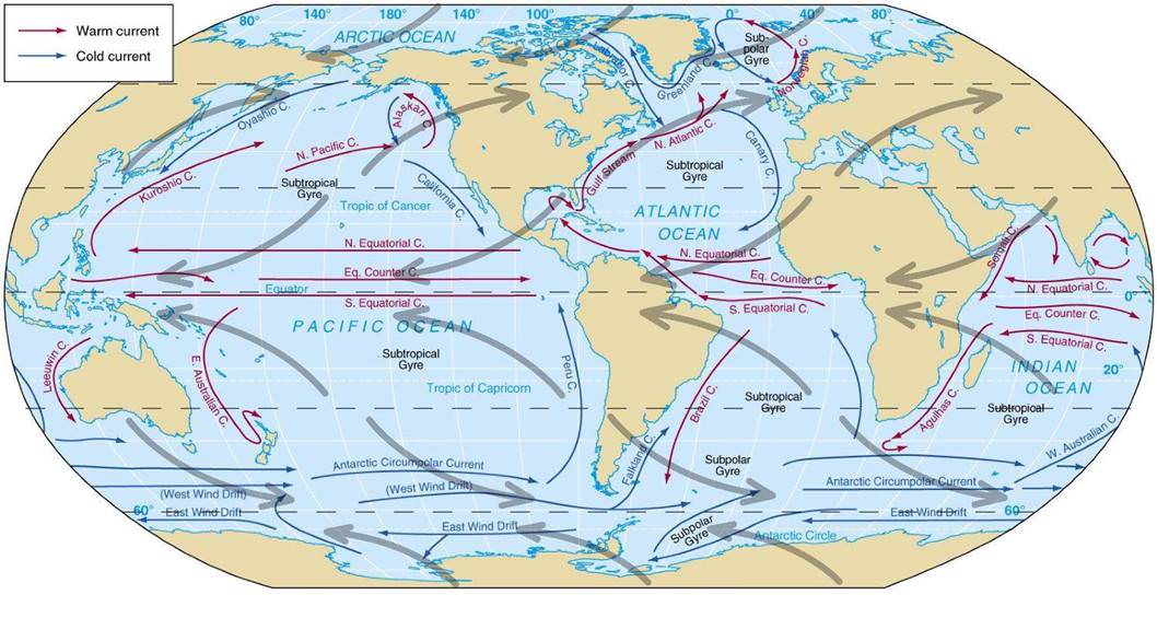

Cold and Warm Ocean Currents
Pacific Ocean Currents


Pacific Ocean Currents
Equatorial currents – warm
- Under the influence of prevailing trade winds [tropical easterlies], the north equatorial current and the south equatorial current start from the eastern Pacific (west coast of Central America) and traverses a distance of 14,500 km moving from east to west.
- This raises the level of western Pacific (near Indonesia and Australia) ocean by few centimetres.
- And this creates a counter-equatorial current which flows between the north equatorial current and the south equatorial current in west-east direction.
Factors that aid the formation of Counter-Equatorial current
- Piling up of water in the western Pacific due to trade winds.
- The presence of doldrums (calm region in equatorial low-pressure belt) in between the north equatorial current and the south equatorial current.
Question Prelims 2015: What explains the eastward flow of the equatorial counter-current?
- The Earth’s rotation on its axis
- Convergence of the two equatorial currents
- Difference in salinity of water
- Occurrence of the belt of calm near the equator
Point 1: Earth’s rotation creates Coriolis force, but Coriolis force is not responsible for counter-current.
Point 2: Convergence is a prerequisite, but not all convergences lead to counter-currents.
Point 3: Salinity greatly influences vertical currents and its influence on horizontal movement is less significant. So, ruled out.
Point 4: This is the main reason behind counter equatorial current (the backward movement of equatorial waters). Doldrums are calm regions facilitating the backward movement of water.
Answer: D
Kuroshio current – warm
- The north equatorial current turns northward off the Philippines to form the Kuroshio current.
- It flows in the sub-tropical high-pressure belt, and its northern part is under the influence of westerlies.
Oyashio Current and Okhotsk current – cold
- Oyashio flows across the east coast of Kamchatka Peninsula to merge with the warmer waters of Kuroshio.
- Okhotsk current flows past Sakhalin Islands to merge with the Oyashio current off Hokkaido (Northern Japanese Island).
- The convergence of cold and warm currents makes the zone one of the richest fishing grounds.
North-Pacific current – warm
- From the south-east coast of Japan, under the influence of prevailing westerlies, the Kuroshio current turns eastwards and moves as the North-Pacific current, reaches the west coast of North America, and bifurcates into two.
Alaska current – warm
- The northern branch of North-Pacific current flows anti-clockwise along the coast of British Columbia and Alaska and is known as the Alaska current.
- The water of this current is relatively warm as compared to the surrounding waters in this zone.
Californian current – cold
- The southern branch of the North-Pacific current moves as a cold current along the west coast of USA and is known as the Californian current.
- The Californian current joins the north equatorial current to complete the circuit.
East Australian current – warm
- Following the pattern in the northern hemisphere, the south equatorial current flows from east to west and turns southwards as the East Australian current.
- It then meets the South Pacific current near Tasmania which flows from west to east.
Peru current or Humboldt Current – cold
- Reaching the south-western coast of South America, South Pacific current turns northward as the Peru current. It is a cold current, which finally feeds the south equatorial current, thus completing the great circuit.
- The zone where Peru Cold current meets the warm equatorial ocean waters is an important fishing zone.
Phytoplankton and Fishing
Mixing zones of Cold and Warm Ocean Currents (Grand Banks) and cold water upwelling zones (Peru coast) are the most productive fishing grounds on earth. Why?
- Phytoplankton are the primary producers in the marine food chain and hence they are called the grass of the sea.
- Phytoplankton are predominantly microscopic, single-celled organisms.
- Some species of algae are large, multicellular and live on the ocean bottom.
- They are insignificant players in the marine ecosystem compared to the phytoplankton as they only inhabit a narrow zone around the coast.


Aquatic Food Web (Left); Types of Phytoplankton (Right)
Why are cold and warm current mixing zones the good fishing grounds? Why are tropical waters highly unproductive?
- Algae and other plants are able to photosynthesise to produce organic material from inorganic nutrients.
- And the organic material forms the building block for all animals higher up in the food chain.
- Almost all biomass in the ocean is derived from the phytoplankton and to a lesser extent the benthic algae (found on the bottom of a sea or lake).
- However, there is a fundamental problem phytoplankton in the open ocean have to face. They need both sunlight and nutrients (such as nitrate and phosphate) to be able to photosynthesise.
- Sunlight is only available in the uppermost layers.
- During photosynthesis, the nutrients are quickly used up by phytoplankton, so they are not available for long periods in the upper layers under normal circumstances.
This is indeed the case in tropical waters, and as a result, they are very unproductive.
- To escape this problem the seawater needs to be mixed regularly to bring the nutrient-rich deep waters up to the sunlight zone where the phytoplankton can grow.


Phytoplankton production is highest at high latitudes
This is one of the reasons why cold and warm currents convergence zones (mixing happens; e.g. Grand Banks) and upwelling zones (e.g. upwelling near Peruvian coast) are very productive.
- Furthermore, in surroundings where atmospheric temperatures are often colder than oceanic temperatures, the top layers of the ocean are cooled by the atmosphere.
- This increases the density of the surface waters and causes them to sink and therefore causes mixing (nutrient deficient water sinks, and nutrient-rich water is upwelled).
Both of these factors play a role in Icelandic waters, resulting in the very productive ocean environment around Iceland.
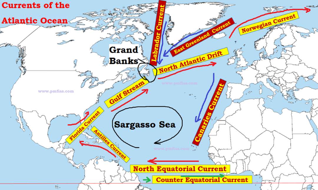
Atlantic Ocean Currents

North Atlantic Ocean Currents
Equatorial Atlantic Ocean Currents – warm
- Under the influence of prevailing trade winds (easterly trade winds), the north equatorial current and the south equatorial current start from the eastern Atlantic (west coast of Africa), moving from east to west.
- This raises the level of western Atlantic (north of the Brazil bulge) ocean by few centimetres.
- And this creates a counter-equatorial current which flows between the north equatorial current and the south equatorial current in west-east direction.
Antilles current – warm
- The south equatorial current bifurcates into two branches near Cape de Sao Roque (Brazil).
- Part of the current enters the Caribbean Sea along with north equatorial current into the Mexican Gulf, while the remainder passes along the eastern side of the West Indies as the Antilles current.
- There is a rise in water level in the Mexican Gulf because of large amounts of water brought by the Mississippi River and branches of north and south equatorial currents.
Gulf Stream and North Atlantic Drift – warm
- Antilles current creates a current that flows out through the Strait of Florida as Florida current, which mixes with Antilles current from the south.
- This combined current moves along the east coast of USA and is known as the Florida current up to the Cape Hatteras and as the Gulf Stream beyond that.
- Near the Grand Banks, the Gulf Stream mixes with cold Labrador and East Greenland currents and flows eastward across the Atlantic as the North Atlantic Drift.
- Here, westerly movement of North Atlantic Drift is due to the influence of westerlies.
Norwegian current – warm
- The North Atlantic Current breaks up into two branches on reaching the eastern part of the ocean.
- The main current, continuing as the North Atlantic Drift, reaches the British Isles from where it flows along the coast of Norway as the Norwegian current and enters the Arctic Ocean.
- Norwegian current is very important as it keeps ocean to the north of Norway partly free from ice and also moderates the extremes of climate.
- It is because of this current, Russia is able to move cargo in summers through Arctic ocean (Barents Sea).
- The southerly branch flows between Spain and Azores as the cold Canary current.
- This current finally joins the north equatorial current completing the circuit in the North Atlantic.
- The Sargasso Sea, lying within this circuit, is full of large quantities of seaweed and is an important geographical feature.

Grand Banks-Richest Fishing Grounds on Earth
- The two cold currents—East Greenland current and the Labrador current—flow from the Arctic Ocean into the Atlantic Ocean.
- The Labrador current flows along part of the east coast of Canada and meets the warm Gulf Stream.
- The confluence of these two currents, one hot and the other cold, produce the famous fogs around Newfoundland.
- As a result of mixing of cold and warm waters, one of the world’s most important fishing grounds is created.


South Atlantic Ocean Currents
Brazil current – warm
- In the South Atlantic Ocean, the south equatorial current, flowing from east to west, splits into two branches near Cape de Sao Roque (Brazil).
- The northern branch joins the north equatorial current (a part of it flows in Antilles Current and other into Gulf of Mexico), whereas the southern branch turns southward and flows along the South American coast as the warm Brazil current.
- The south-flowing Brazil current swings eastward at about latitude 35°S (due to westerlies) to join the West Wind Drift flowing from west to east.
- A small branch of West Wind Drift splits and flows between Argentinian coast and Falkland Islands, and this current is called as Falkland cold current.
- It mixes with warm Brazil current at the southern tip of Brazil.
Benguela current – cold current
- A branch of the South Atlantic splits at the southern tip of Africa and flows along the west coast of South Africa as the cold Benguela current, which joins the south equatorial current to complete the circuit.
Prelims 1999: In the given map, which one of the following pairs of ocean currents are shown?

- Bengula and Falkland
- Canary and Humboldt
- Agulhas and Guinea
- Benguela and Guinea
Indian Ocean Currents
- Indian ocean is half an ocean, hence the behaviour of the North Indian Ocean Currents is different from that of Atlantic Ocean Currents or the Pacific Ocean Currents.
- Also, monsoon winds in Northern Indian ocean are peculiar to the region, which directly influence the ocean surface water movement (North Indian Ocean Currents)
Indian Ocean Currents and Monsoons
- The currents in the northern portion of the Indian Ocean change their direction from season to season in response to the seasonal rhythm of the monsoons.
- The effect of winds is comparatively more pronounced in the Indian Ocean.
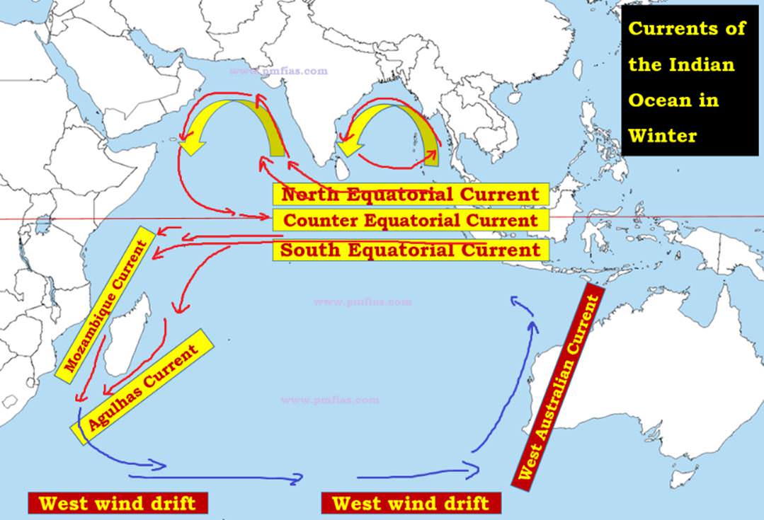

North Indian Ocean Currents
Winter Circulation
- Under the influence of prevailing trade winds, the north equatorial current and the south equatorial current start from the south of Indonesian islands, moving from east to west.
- This raises the level of western Indian (south-east of horn of Africa) ocean by few centimetres.
- And this creates a counter-equatorial current which flows between the north equatorial current and the south equatorial current in west-east direction.
- The north-east monsoons drive the water along the coast of Bay of Bengal to circulate in an anti-clockwise direction.
- Similarly, the water along the coast of Arabian Sea also circulate in an anti-clockwise circulation.
Summer Circulation – North Equatorial Current & Counter-Equatorial Current are Absent
- In summer, due to the effects of the strong south-west monsoon and the absence of the north-east trades, a strong current flow from west to east, which completely obliterates the north equatorial current.
- Hence, there is no counter-equatorial current as well.
- Thus, the circulation of water in the northern part of the ocean is clockwise during this season.


South Indian Ocean Currents
Southern Indian Ocean Currents
- The general pattern of circulation in southern part of the Indian Ocean is quite similar to that of southern Atlantic and Pacific oceans. It is less marked by the seasonal changes.
- The south equatorial current, partly led by the corresponding current of the Pacific Ocean, flows from east to west.
- It splits into two branches, one flowing to the east of Madagascar known as Agulhas current and the other between Mozambique and Western Madagascar coast known as Mozambique current.
- At the southern tip of Madagascar, these two branches mix and are commonly called as the Agulhas current. It still continues to be a warm current, till it merges with the West Wind Drift.
- The West Wind Drift, flowing across the ocean in the higher latitudes from west to east, reaches the southern tip of the west coast, of Australia.
- One of the branches of this cold current turns northwards along the west coast of Australia. This current, known as the West Australian current, flows northward to feed the south equatorial current.
Effects of Ocean Currents
- Ocean currents have a number of direct and indirect influences on human activities.
Desert formation
- Cold ocean currents have a direct effect on desert formation in west coast regions of the tropical and sub-tropical continents.
- There is fog, and most of the areas are arid due to desiccating effect (loss of moisture ― fog or temperature inversion inhibits convection).
Rains
- Warm ocean currents bring rain to coastal areas and even interiors. Example: Summer Rainfall in British Type climate (North Atlantic Drift).
- Warm currents flow parallel to the east coasts of the continents in tropical and subtropical latitudes. This results in warm and rainy climates. These areas lie in the western margins of the subtropical anti-cyclones.
Moderating effect
- They are responsible for moderate temperatures at coasts. (North Atlantic Drift brings warmness to England. Canary cold current brings cooling effect to Spain, Portugal etc.)
Fishing
- Mixing of cold and warm ocean currents bear richest fishing grounds in the world.
- Example: Grand Banks around Newfoundland, Canada and North-Eastern Coast of Japan.
- The mixing of warm and cold currents helps to replenish the oxygen and favour the growth of planktons, the primary food for fish population.
- The best fishing grounds of the world exist mainly in these mixing zones.
Drizzle
- Mixing of cold and warm ocean currents create foggy weather where precipitation occurs in the form of drizzle (Newfoundland).
Climate
- Warm and rainy climates in tropical and subtropical latitudes (Florida, Natal etc.),
- Cold and dry climates on the western margins in the sub-tropics due to desiccating effect,
- Foggy weather and drizzle in the mixing zones,
- Moderate clime along the western costs in the sub-tropics.
Tropical cyclones
- They pile up warm waters in tropics, and this warm water is the major force behind tropical cyclones.
Navigation
- Currents are referred to by their “drift”. Usually, the currents are strongest near the surface and may attain speeds over five knots (1 knot = ~1.8 kmph).
- At depths, currents are generally slow with speeds less than 0.5 knots.
- Ships usually follow routes which are aided by ocean currents and winds.
- Example: If a ship wants to travel from Mexico to Philippines, it can use the route along the North Equatorial Drift which flows from east to west.
- When it wants to travel from Philippines to Mexico, it can follow the route along the doldrums when there is counter equatorial current flowing from west to east.
Explain the factors responsible for the origin of ocean currents. How do they influence regional climates, fishing and navigation? (Mains 2015)
Desert Formation and Ocean Currents
Mains 2013: Major hot deserts in northern hemisphere are located between 20-30 degree north and on the western side of the continents. Why?
- Major hot wind deserts include the biggest Sahara Desert (3.5 million square miles). The next biggest desert is the Great Australian Desert.
- The other hot deserts are the Arabian Desert, Iranian Desert, Thar Desert, Kalahari and Namib Deserts.
- The aridity of the hot deserts is mainly due to the effects of off-shore Trade Winds; hence they are also called Trade Wind Deserts.
Why between 20 – 30 degree?
- The hot deserts lie along the Horse Latitudes or the Sub-Tropical High-Pressure Belts where the air is descending, a condition least favourable for precipitation of any kind to take place.
Offshore winds
- The rain-bearing Trade Winds blow off-shore and the Westerlies that are on-shore blow outside the desert limits (outside tropics).
- Whatever winds reach the deserts blow from cooler to warmer regions, and their relative humidity is lowered, making condensation almost impossible.
- Under such conditions, every bit of moisture is evaporated.
Why on western coast?
- On the western coasts, the presence of cold currents gives rise to mists and fogs by chilling the on-coming air. This inhibits convection in the air (because of temperature inversion).
- This air is later warmed by contact with the hot land, and little rain falls.
- The desiccating effect of the cold Peruvian Current along the Chilean coast is so pronounced that the mean annual rainfall for the Atacama Desert is not more than 1.3 cm.
Tides
- The periodical rise and fall of the sea level, once or twice a day, mainly due to the attraction of the sun and the moon, is called a tide.
- The study of tides is very complex, spatially and temporally, as it has great variations in frequency, magnitude and height.
- The moon’s gravitational pull to a great extent and to a lesser extent the sun’s gravitational pull, are the major causes for the occurrence of tides.
- Another factor is centrifugal force which acts opposite to gravitational pull of earth.
- Tides occur due to a balance between all these forces.
Tidal Bulge: Why there are two tidal bulges?


Formation of Tidal Bulges
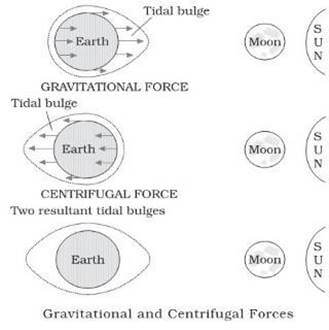
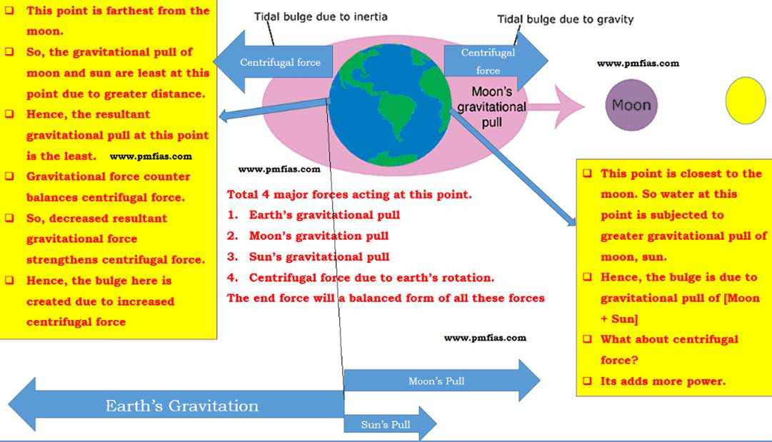
- Together, the gravitational pull and the centrifugal force are responsible for creating the two major tidal bulges on the earth.
- The ‘tide-generating’ force is the difference between these two forces; i.e. the gravitational attraction of the moon and the centrifugal force.
- On the surface of the earth nearest to the moon, pull or the attractive force of the moon is greater than the centrifugal force, and so there is a net force causing a bulge towards the moon.
Why is there a tidal bulge on the other side?
- On the opposite side of the earth, the attractive force is less, as it is farther away from the moon, the centrifugal force is dominant. Hence, there is a net force away from the moon.
- This creates the second bulge away from the moon.
Factors Controlling the Nature and Magnitude of Tides
- The movement of the moon in relation to the earth.
- Changes in position of the sun and moon in relation to the earth.
- Uneven distribution of water over the globe.
- Irregularities in the configuration of the oceans.
Types of Tides
- Tides vary in their frequency, direction and movement from place to place and also from time to time.
- Tides may be grouped into various types based on their frequency of occurrence in one day or 24 hours or based on their height.
Tides based on Frequency
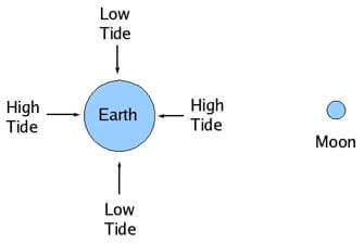
Semi-diurnal tide
- It is the most common tidal pattern, featuring two high tides and two low tides each day (it varies between 3 tides to 4 tides –– 3 tides in rare cases but 4 is normal).
- The successive high or low tides are approximately of the same height.


High tide and low tide (Wikipedia). Hide tides and low tides are formed due to earth’s rotation relative to moon
Ebb and Flood
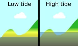
- The time between the high tide and low tide, when the water level is falling, is called the ebb.
- The time between the low tide and high tide, when the tide is rising, is called the flow or flood.


Flood (between low tide and high tide)


Ebb (between high tide and low tide)
Although tides occur twice a day, their interval is not exactly 12 hours. Instead, they occur at regular intervals of 12 hours and 25 minutes. (This is because of the changing relative positions of the moon and the sun)
- This is because the moon revolves around the earth from west to east, and each day it moves a bit to the east if observed from the same place on earth at the same time on two consecutive days.
- This time lag explains the tide interval of 12 hours and 25 minutes, as tides occur twice a day.
- Southampton experiences tides 6-8 times a day (2 high tides from North Sea + 2 high tides from English Channel + 2 low tides from North Sea + 2 low tides from English Channel).
- This happens because the North Sea and the English Channel push the water at different intervals.


Southampton
Diurnal tide
- There is only one high tide and one low tide during each day.
- The successive high and low tides are approximately of the same height.
Mixed tide
- Tides having variations in height are known as mixed tides. These tides generally occur along the west coast of North America and on many islands of the Pacific Ocean.
Tides based on the Sun, Moon and the Earth Positions
- The height of rising water (high tide) varies appreciably depending upon the position of sun and moon with respect to the earth. Spring tides and neap tides come under this category.
Spring tides
- The position of both the sun and the moon in relation to the earth has direct bearing on tide height.
- When the sun, the moon and the earth are in a straight line, the height of the tide will be higher.
- These are called spring tides and they occur twice a month, one on full moon period and another during new moon period.

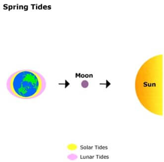


Spring Tides (New Moon and Full Moon)
Neap tides
- Normally, there is a seven-day interval between the spring tides and neap tides.
- At this time the sun and moon are at right angles to each other, and the forces of the sun and moon tend to counteract one another.
- The Moon’s attraction, though more than twice as strong as the sun’s, is diminished by the counteracting force of the sun’s gravitational pull.
- Like spring tides, these tides also occur twice a month.


Neap tide (Half Moon – First Quarter and Last Quarter)
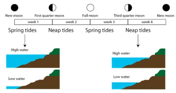

Spring tide: high tide is higher than normal; low tide is lower than normal
Neap tide: high tide is lower than normal; low tide is higher than normal
Magnitude of tides based on Perigee and Apogee
- Once in a month, when the moon’s orbit is closest to the earth (perigee), unusually high and low tides occur. During this time the tidal range is greater than normal.
- Two weeks later, when the moon is farthest from earth (apogee), the moon’s gravitational force is limited, and the tidal ranges are less than their average heights.


Perigee and Apogee
Magnitude of tides based on Perihelion and Aphelion
- When the earth is closest to the sun (perihelion), around 3rd January each year, tidal ranges are also much greater, with unusually high and unusually low tides.
- When the earth is farthest from the sun (aphelion), around 4th July each year, tidal ranges are much less than average.
Importance of Tides
- Since tides are caused by the earth-moon-sun positions which are known accurately, the tides can be predicted well in advance. This helps the navigators and fishermen plan their activities.
Navigation
- Tidal heights are very important, especially harbours near rivers and within estuaries having shallow ‘bars’ at the entrance, which prevent ships and boats from entering into the harbour.
- High tides help in navigation. They raise the water level close to the shores. This helps the ships to arrive at the harbour more easily.
- Tides generally help in making some of the rivers navigable for ocean-going vessels. Port of London and Haldia Port, Kolkata (tidal ports) have become important ports owing to the tidal nature of the mouths of the Thames and Hooghly respectively.
Fishing
- The high tides also help in fishing. Many more fish come closer to the shore during the high tide. This enables fishermen to get a plentiful catch.
Desilting
- Tides are also helpful in desilting the sediments and in removing polluted water from river estuaries.
Other
- Tides are used to generate electrical power (in Canada, France, Russia, and China).
- A 3 MW tidal power project was constructed at Durgaduani in Sundarbans of West Bengal.
Characteristics of Tides
- On the surface of the earth, the horizontal tide-generating forces are more important than the vertical forces in generating the tidal bulges.
- The tidal bulges on wide continental shelves have greater height. When tidal bulges hit the mid-oceanic islands, they become low.
- The shape of bays and estuaries along a coastline can also magnify the intensity of tides.


Landform affected by tides
- When the tide is channelled between islands or into bays and estuaries, they are called tidal currents (tidal bore is one such tidal current).
- Funnel-shaped bays greatly change tidal magnitudes. Example: Bay of Fundy –– Highest tidal range.
- The highest tides occur in the Bay of Fundy in Nova Scotia, Canada. The tidal bulge is 15-16 m.


Bay of Fundy in Nova Scotia, Canada
Tidal bore
- Tides also occur in gulfs. The gulfs with wide fronts and narrow rears experience higher tides.
- The in and out movement of water into a gulf through a channel is called a tidal current.


Tidal bore
- When a tide enters the narrow and shallow estuary of a river, the front of the tidal wave appears to be vertical owing to the piling up of water of the river against the tidal wave and the friction of the river bed.
- The steep-nosed tide crest looks like a vertical wall of water rushing upstream and is known as a tidal bore.
- The favourable conditions for tidal bore include strength of the incoming tidal wave, slim and depth of the channel and the river flow.
- There are exceptions. The Amazon River is the largest river in the world. It empties into the Atlantic Ocean. The mouth of the Amazon is not narrow, but the river still has a strong tidal bore.
- A tidal bore develops here because the mouth of the river is shallow and dotted by many low-lying islands and sand bars.
- In India, tidal bores are common in the Hooghly river.
- Most powerful tidal bores occur in Qiantang River in China.


Enormous Tidal bore
- The name ‘bore’ is because of the sound the tidal current makes when it travels through narrow channels.
- Bores occur in relatively few locations worldwide, usually in areas with a large tidal range, typically more than 6 metres (20 ft) between high and low water.
- A tidal bore takes place during the flood tide and never during the ebb tide (Tidal bores almost never occur during neap tides).
Impact of Tidal Bore
- Tides are stable and can be predicted. Tidal bores are less predictable and hence can be dangerous.
- The tidal bores adversely affect the shipping and navigation in the estuarine zone.
- Tidal bores of considerable magnitude can capsize boats and ships of considerable size.
- Strong tidal bores disrupt fishing zones in estuaries and gulfs.
- The tidal-bore affected estuaries are the rich feeding zones and breeding grounds of several forms of wildlife. Tidal bores have an adverse impact on the ecology of estuaries.
- Animals slammed by the leading edge of a tidal wave can be buried in the silty water. For this reason, carnivores and scavengers are common sights behind tidal bores.
Multiple Choice Questions
1. Upward and downward movement of ocean water is known as the:
(a) tide
(b) wave
(c) current
(d) none of the above
2. Neap tides are caused:
(a) As result of the moon and the sun pulling the earth gravitationally in the same direction.
(b) As result of the moon and the sun pulling the earth gravitationally in the opposite direction.
(c) Indention in the coastline.
(d) None of the above.
3. The distance between the earth and the moon is minimum when the moon is in:
(a) Aphelion
(b) Perihelion
(c) Perigee
(d) Apogee
4. The earth reaches its perihelion in:
(a) October
(b) July
(c) September
(d) January
Answers: 1. A) Tide 2. D) None 3. C) Perigee 4. B) July
Temperature Distribution of Oceans
- The study of the temperature of the oceans is important for determining the
- movement of large volumes of water (vertical and horizontal ocean currents),
- type and distribution of marine organisms at various depths of oceans,
- climate of coastal lands, etc.
Source of Heat in Oceans
- The sun is the principal source of energy (Insolation).
- The ocean is also heated by the inner heat of the ocean itself (at the ocean bottom, the crust is only about 5 to 30 km thick). But this heat is negligible compared to that received from sun.
The ocean water is heated by three processes
- Absorption of sun’s radiation.
- The conventional currents: Since the temperature of the earth increases with increasing depth, the ocean water at great depths is heated than the subsurface and intermediate water layers.
- Also, the temperate are high along mid-ocean ridges because of volcanism.
- So, convectional oceanic circulations develop causing circulation of heat in water.
- Heat is produced due to friction caused by the surface wind and the tidal currents.
The ocean water is cooled by
- Back radiation (heat budget) or long wave terrestrial radiation from the seawater.
- Exchange of heat between the sea and the atmosphere if there is temperature difference.
- Evaporation: Heat is lost in the form of latent heat of evaporation (atmosphere gains this heat in the form of latent heat of condensation).
How does deep water marine organisms survive in spite of absence of sunlight?
- Photic zone (the zone that receives sunlight) is only about few hundred meters.
- It depends on a lot of factors like turbidity, presence of algae etc.
- There are no enough primary producers below few hundred meters till the ocean bottom.
- At the sea bottom, there are bacteria that make use of heat supplied by earth’s interior to prepare food. So, they are the primary producers at the depths.
- Other organisms feed on these primary producers and subsequent secondary producers.
- So, the heat from earth supports wide-ranging deep water marine organisms.
But the productivity is too low compared to ocean surface.
Why is diurnal range of ocean temperatures too small?
- The process of heating and cooling of the oceanic water is slower than land due to vertical and horizontal mixing and high specific heat of water.
- (More time is required to heat a Kg of water compared to heating the same unit of a solid at same temperatures and with equal energy supply).
Factors Affecting Temperature Distribution of Oceans
- Insolation: The average daily duration of insolation and its intensity.
- Heat loss: The loss of energy by reflection, scattering, evaporation and radiation.
- Albedo: The albedo of the sea (depending on the angle of sun rays).
- The physical characteristics of the sea surface: Boiling point of the sea water is increased in the case of higher salinity and vice versa (if Salinity is increased 🡺 Boiling point will increase 🡺 Evaporation will decrease).
- The presence of submarine ridges and sills: Temperature is affected due to lesser mixing of waters on the opposite sides of the ridges or sills (e.g. subsurface layers in Mediterranean Sea).
- The shape of the ocean (enclosed seas): enclosed seas in the low latitudes record relatively higher temperature than the open seas (due to less mixing and higher overall insolation); whereas the enclosed seas in the high latitudes have lower temperature than the open seas.
- E.g. Mediterranean Sea records higher temperature than the longitudinally extensive Gulf of California.
- Local weather conditions such as cyclones.
- Unequal distribution of land and water: The oceans in the northern hemisphere receive more heat due to their contact with larger extent of land than the oceans in the southern hemisphere.
- Prevalent winds generate horizontal and sometimes vertical ocean currents: The winds blowing from the land towards the oceans (off-shore winds: moving away from the shore) drive warm surface water away from the coast resulting in the upwelling of cold water from below (this happens near Peruvian Coast during normal years).
- Contrary to this, the onshore winds (winds flowing from oceans into continents) pile up warm water near the coast, and this raises the temperature (this happens near the Peruvian coast during El Nino event).
- Ocean currents: Warm ocean currents raise the temperature in cold areas while the cold currents decrease the temperature in warm ocean areas.
- Gulf stream (warm current) raises the temperature near the eastern coast of North America and the West Coast of Europe while the Labrador current (cold current) lowers the temperature near the north-east coast of North America (Near Newfoundland).
Vertical Temperature Distribution of Oceans
- Photic or euphotic zone extends from the upper surface to ~200 m. The photic zone receives adequate solar insolation.
- Aphotic zone extends from 200 m to the ocean bottom; this zone does not receive adequate sunrays.
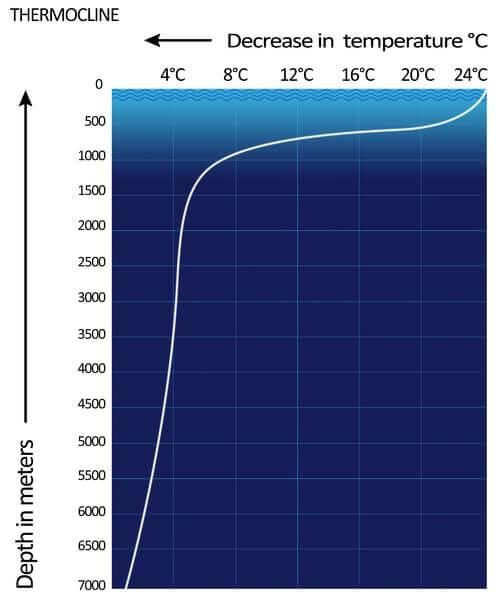

Thermocline (Praveenron, Wikipedia)
Thermocline
- The profile shows a boundary region between the surface waters of the ocean and the deeper layers.
- The boundary usually begins around 100-400 m below the sea surface and extends several hundred of meters downward.
- This boundary region, from where there is a rapid decrease of temperature, is called the thermocline.
- About 90 per cent of the total volume of water is found below the thermocline in the deep ocean. In this zone, temperatures approach 0° C.
Three-Layer System
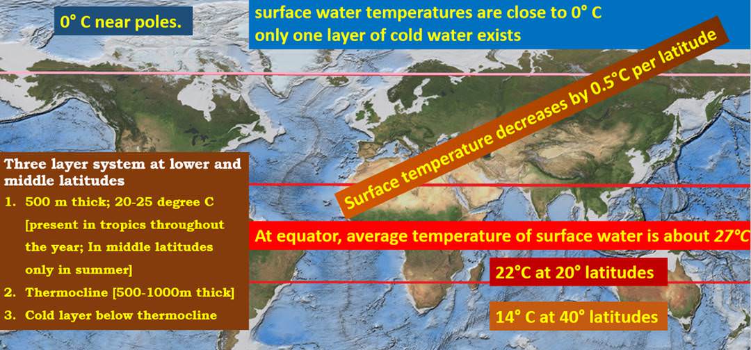
- The temperature structure of oceans over middle and low latitudes can be described as a three-layer system from surface to the bottom.
- The first layer represents the top layer of warm oceanic water, and it is about 500m thick with temperatures ranging between 20° and 25° C.
- This layer, within the tropical region, is present throughout the year but in mid-latitudes, it develops only during summer.
- The second layer called the thermocline layer lies below the first layer and is characterized by rapid decrease in temperature with increasing depth. The thermocline is 500-1,000 m thick.
- The third layer is very cold and extends up to the deep ocean floor. Here the temperature becomes almost stagnant.
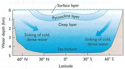
Pycnocline
- Pycnocline is a boundary separating two liquid layers of different densities.
- Pycnocline exists in oceans at a depth of 100-1000 m because of large density difference between surface waters and deep ocean water.
- Pycnocline effectively prevents vertical currents except in polar regions.
- Pycnocline is almost absent in polar regions. This is because of the sinking of cold water near poles.
- Formation of pycnocline may result from changes in salinity or temperature.
- Because the pycnocline zone is extremely stable, it acts as a barrier for surface processes.
- Thus, changes in salinity or temperature are very small below pycnocline but are seasonal in surface waters.

Pycnocline
Similar Terms: Thermocline, Halocline.
Thermohaline Circulation
- Winds drive ocean currents in the upper 100 meters of the ocean’s surface.
- However, ocean currents also flow thousands of meters below the surface.
- These deep-ocean currents are driven by differences in the water’s density, which is controlled by temperature (thermo) and salinity (haline).
- This process is known as thermohaline circulation.
- The thermohaline circulation is sometimes called the ocean conveyor belt, the great ocean conveyor, or the global conveyor belt.
- Ocean bottom relief greatly influences thermohaline circulation.


Thermohaline Circulation (Wikipedia)
Horizontal Temperature Distribution
- The average temperature of surface water of the oceans is about 27°C, and it gradually decreases from the equator towards the poles.
- The rate of decrease of temperature with increasing latitude is generally 0.5°C per latitude.

Ocean Temperature Distribution
General behaviour
- In the Arctic and Antarctic circles, the surface water temperatures are close to 0° C and so the temperature change with the depth is very slight (ice is a very bad conductor of heat).
- Here, only one layer of cold water exists, which extends from surface to deep ocean floor.
The rate of decrease of temperature with depths is greater at the equator than at the poles.
- The surface temperature and its downward decrease is influenced by the upwelling of bottom water (e.g. near Peruvian coast during normal years).
- In cold Arctic and Antarctic regions, sinking of cold water and its movement towards lower latitudes is observed.
- In equatorial regions the surface, water sometimes exhibits lower temperature and salinity due to high rainfall, whereas the layers below it has higher temperatures.
- The enclosed seas in both the lower and higher latitudes record higher temperatures at the bottom.
- The enclosed seas of low latitudes like the Sargasso Sea, the Red Sea and the Mediterranean Sea have high bottom temperatures due to high insolation throughout the year and lesser mixing.
- In the case of the high latitude enclosed seas, the bottom layers of water are warmer as water of slightly higher salinity and temperature moves from outer ocean as a sub-surface current.
- The presence of submarine barriers may lead to different temperature conditions on the two sides of the barrier.
- For example, at the Strait of Bab-el-Mandeb, the submarine barrier (sill) has a height of about 366 m.
- The subsurface water in the strait is at high temperature compared to water at same level in Indian ocean. The temperature difference is greater than nearly 20° C.
Range of Ocean Temperature
- The oceans and seas get heated and cooled slower than the land surfaces.
- Therefore, ocean surface temperature is highest at 2 p.m. and the lowest, at 5 a.m.
- The average diurnal or daily range of temperature is barely 1 degree in oceans and seas.
- The annual range of temperature is influenced by the annual variation of insolation, the nature of ocean currents and the prevailing winds.
- The maximum and the minimum temperatures in oceans are slightly delayed than those of land areas (the maximum being in August and the minimum in February (tropical cyclones occur mostly between August and October. It is slightly different in Indian Ocean due to its shape).
- The northern Pacific and northern Atlantic oceans (less intense prevailing winds) have a greater range of temperature than their southern parts (more extensive ocean currents).
- Besides annual and diurnal ranges of temperature, there are periodic fluctuations of sea temperature also.
- For example, the 11-year sunspot cycle causes sea temperatures to rise after a 11-year gap.
Ocean Salinity
- Salinity is the term used to define the total content of dissolved salts in seawater.
- It is calculated as the amount of salt (in gm) dissolved in 1,000 gm (1 kg) of seawater.
- It is usually expressed as parts per thousand or ppt.
- Salinity of 24.7 ppt (the symbol for ppt is ‰) has been considered as the upper limit to demarcate ‘brackish water’.
- Salinity determines compressibility, thermal expansion, temperature, density, absorption of insolation, evaporation and humidity.
- It also influences the composition and movement of the sea: water and the distribution of fish and other marine resources.
Share of different salts is as shown below
- sodium chloride — 77.7%
- magnesium chloride—10.9%
- magnesium sulphate — 4.7%
- calcium sulphate — 3.6%
- potassium sulphate — 2.5%
Dissolved Salts in Sea Water (gm of Salt per kg of Water)
|
18.97 |
|
10.47 |
|
2.65 |
|
1.28 |
|
0.41 |
|
0.38 |
Factors Affecting Ocean Salinity
- The salinity of water in the surface layer of oceans depend mainly on evaporation and precipitation.
- Surface salinity is greatly influenced in coastal regions by the freshwater flow from rivers, and in polar regions by the processes of freezing and thawing of ice.
- Wind also influences salinity of an area by transferring water to other areas.
- The ocean currents contribute to the salinity variations.
- Salinity, temperature and density of water are interrelated. Hence, any change in the temperature or density influences the salinity of an area.
Horizontal distribution of salinity
All values are in ppt (parts per thousand or ‰)
- The salinity for normal open ocean ranges between 33 and 37.


Ocean surface salinity (Source)
- The regions of high salinity in vast oceans coincide with high-pressure cells.
- Here, there is hardly any rain and subsiding dry winds cause lots of evaporation.
High salinity regions
- In the landlocked Red Sea, it is as high as 41.
- In the Mediterranean Sea in Europe the salinity is very high – 38 or more.
- In hot and dry regions, where evaporation is high, the salinity sometimes reaches to 70.
Low salinity regions
- In the estuaries (enclosed mouth of a river where fresh and saline water get mixed) and the Arctic and Antarctic, the salinity fluctuates from 0 to 35, seasonally (fresh water coming from ice caps).
Atlantic
- The average salinity of the Atlantic Ocean is around 36-37.
- The equatorial region of the Atlantic Ocean has a salinity of about 35.
- Near the equator, there is heavy rainfall, high relative humidity, cloudiness and calm air of the doldrums.
- The polar areas experience very little evaporation and receive large amounts of fresh water from the melting of ice. This leads to low levels of salinity, ranging between 20 and 32.
- Maximum salinity (37) is observed between 20° N and 30° N and 20° W – 60° W (high-pressure cells).
Indian Ocean
- The average salinity of the Indian Ocean is 35.
- The low salinity trend is observed in the Bay of Bengal due to influx of river water by the river Ganga.
- On the contrary, the Arabian Sea shows higher salinity due to high evaporation and low influx of fresh water.
Marginal seas
- The North Sea, in spite of its location in higher latitudes, records higher salinity due to more saline water brought by the North Atlantic Drift.
- Baltic Sea records low salinity due to influx of river waters in large quantity.
- The Mediterranean Sea records higher salinity due to high evaporation.
- Salinity is, however, very low in Black Sea due to enormous freshwater influx by rivers.
Inland seas and lakes
- The salinity of the inland seas and lakes is very high because of the regular supply of salt by the rivers falling into them.
- These water bodies becomes progressively more saline due to evaporation.
- For instance, the salinity of the Great Salt Lake, (Utah, USA), the Dead Sea and the Lake Van in Turkey is more than 200.
Highest salinity in water bodies
- Lake Van in Turkey (330 ppt)
- Dead Sea (238 ppt)
- Great Salt Lake, Utah (220 ppt)
Cold and warm water mixing zones
- Salinity decreases from 35 to 31 on the western parts of the northern hemisphere because of the influx of melted water from the Arctic region.
Vertical Distribution of Salinity
- With depth, the salinity also varies, but this variation again is subject to latitudinal difference.
- The decrease is also influenced by cold and warm currents.
- In high latitudes, salinity increases with depth. In the middle latitudes, it increases up to 35 metres and then it decreases. At the equator, sub-surface salinity is lower.
- Salinity, generally, increases with depth and there is a distinct zone called the halocline (compare this with thermocline), where salinity increases sharply.
- High salinity seawater general, sinks below the lower salinity water. This leads to stratification by salinity.
Questions
- Salinity is expressed as the amount of salt in grams dissolved in seawater per (a) 10 gm (b) 1,000 gm (c) 100 gm (d) 10,000 gm
- Which one of the following is the smallest ocean? (a) Indian Ocean (b) Arctic Ocean (c) Atlantic Ocean (d) Pacific Ocean
Answers: 1. B) 1000 gm 2. B) Arctic
Coral Reefs
- Coral reefs are made up of calcareous skeletons of thousands of tiny marine organisms called coral polyps
- Polyps are related to anemones and jellyfish.
- They are shallow warm water organisms which have a soft body covered by a calcareous skeleton.
- The polyps extract calcium salts from seawater to form these hard skeletons.
- The polyps live in colonies fastened to the rocky seafloor.
- The tubular skeletons grow as a cemented calcareous rocky mass, collectively called corals.
- When the coral polyps die, they shed their skeleton (coral) on which new polyps grow.
- The cycle is repeated for over millions of years leading to accumulation of layers of corals.
- Shallow rock layers created by the depositions of corals is called a coral reef.
- Coral reefs over a period of time transform or evolve into coral islands (e.g. Lakshadweep).
- The corals occur in different forms and colours, depending upon the nature of salts they are made of.
- Small marine plants (algae) also deposit calcium carbonate contributing to coral growth.
Coral Reef Relief Features
- Fringing reef, barrier reef and atoll (coral islands are formed on atolls) are the most important relief features.


Coral Reef Relief Features
Fringing Reefs (Shore Reefs)
- Fringing reefs are reefs that grow directly from a shore.
- They are very narrow (1-2 km wide) and are located very close to the land.
- A shallow lagoon exists between the beach and the main body of the reef.
A lagoon refers to a comparatively wide band of water that lies between the shore and the main area of reef development and contains at least some deep portions.
- Fringing reef grows from the deep sea bottom with the seaward side sloping steeply into the deep sea.
- Coral polyps do not extend outwards because of sudden and large increase in depth.
- The fringing reef is by far the most common of the three major types of coral reefs.
- Fringing reefs can be seen at the New Hebrides Society islands off Australia and off the southern coast of Florida.
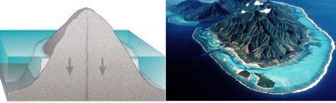

Fringing Reef
Barrier Reefs
- Barrier reefs are extensive linear reefs that run parallel to the shore and are separated from it by a lagoon.
- This is the largest (in size, not distribution) of the three reefs, runs for hundreds of kilometres and is several kilometres wide.
- It extends as a broken, irregular ring around the coast or an island, running almost parallel to it.
- Barrier reefs are far less common than fringing reefs or atolls.
- The 1200-mile long Great Barrier Reef off the NE coast of Australia is the world’s largest barrier reef.
- The GBR is not a single reef, but rather a very large complex consisting of many reefs.
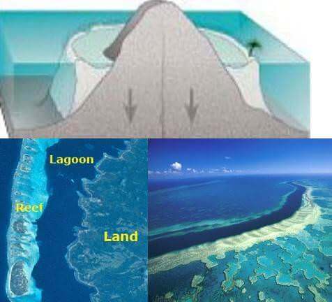

Barrier Reef
Atolls
- An atoll is a roughly circular oceanic reef system surrounding a large central lagoon.
- The lagoon has a depth of 80-150 metres and may be joined with sea water through a number of channels cutting across the reef.
- Atolls are located at great distances from deep sea platforms.
- They form on submarine features such as a submerged island or a volcanic cone which reaches a level suitable for coral growth.
- An atoll may have any one of the following three forms-
- true atoll: a circular reef enclosing a lagoon with no island;
- an atoll surrounding a lagoon with an island;
- a coral island or an atoll island which is, in fact, an atoll reef, built by the process of erosion and deposition of waves with island crowns formed on them.
- Atolls are far more common in the Pacific than any other ocean.
- The Fiji atoll is a well-known example of atolls.
- In the South Pacific, most atolls occur in mid-ocean. Examples of this reef type are common in French Polynesia, the Caroline and Marshall Islands, Micronesia, and the Cook Islands.
- A large number of atolls occur in the Lakshadweep Islands.
- Others are found in the Maldives and Chagos island groups, the Seychelles, and in the Cocos s.


Atoll
Development of Major Coral Reef Types
Formation of Lakshadweep Islands (You must include the concept of Reunion Hotspot)
- The basic coral reef classification scheme described earlier was first proposed by Charles Darwin and is still widely used today.
- Step 1: A fringing reef forms first and starts growing in the shallow waters close to a tropical island.
- Step 2: Over time, the island subsides, and the reef grows outwards, and the distance between the land and the reef increases. The fringing reef develops into a barrier reef.
- Step 3: If the island completely subsides, all that is left is the reef. The reef retains the approximate shape of the island it grew around, forming a ring enclosing a lagoon (atoll).


Development of Major Coral Reef Types
Ideal Conditions for Coral Growth
- Stable climatic conditions: Corals are highly susceptible to quick changes. They grow in regions where climate is significantly stable for a long period (Equatorial oceans with warm ocean currents).
- Perpetually warm waters: Corals thrive in tropical waters (30°N and 30°S latitudes, the temperature of water is around 20°C) where diurnal and annual temperature ranges are very narrow.
Why are coral reefs absent on west coast of tropical continents? Because of Cold Ocean Currents.
- Shallow water: Coral require fairly good amount of sunlight to survive. The ideal depths for coral growth are 45 m to 55 m below sea surface, where there is enough sunlight available.
- Clear salt water: Clear salt water is suitable for coral growth, while both freshwater and highly saline water are harmful.
- Abundant Plankton: Adequate supply of oxygen and microscopic marine food, called plankton (phytoplankton), is essential for growth. As the plankton is more abundant on the seaward side, corals grow rapidly on the seaward side.
- Little or no pollution: Corals are highly fragile and are vulnerable to climate change and pollution and even a minute increase in marine pollution can be catastrophic.
Distribution of Coral Reefs


Distribution of Coral Reefs
Corals and Zooxanthellae
- Many invertebrates, vertebrates, and plants live in close association with corals, with tight resource coupling and recycling, allowing coral reefs to have extremely high productivity and biodiversity, such that they are referred to as the Tropical Rainforests of the Oceans.
- Scleractinian corals build skeletons of calcium carbonate sequestered from the water.
- Scleractinian corals come under Phylum Cnidaria, and they receive their nutrient and energy resources in two ways.
- They use the traditional cnidarian strategy of capturing tiny planktonic organisms with their tentacles.
- Having a symbiotic relationship with a single cell alga known as zooxanthellae.
- Zooxanthellae are autotrophic (prepare their own food) microalgae belonging to various taxa in the Phylum Dinoflagellata.
Coral 🡺 Phylum Cnidaria
Zooxanthellae 🡺 Phylum Dinoflagellata
Symbiotic Relationship Between Corals and Zooxanthellae
- Zooxanthellae live symbiotically within the coral polyp tissues and assist the coral in nutrient production through its photosynthetic activities.
- These activities provide the coral with fixed carbon compounds for energy, enhance calcification, and mediate elemental nutrient flux.
- The host coral polyp in return provides zooxanthellae with a protected environment to live within, and a steady supply of carbon dioxide for its photosynthetic processes.
- The symbiotic relationship allows the slow-growing corals to compete with the faster growing multicellular algae.
- The corals feed by day through photosynthesis and by night through predation.
The tissues of corals themselves are actually not the beautiful colours of the coral reef but are instead clear. The corals receive their colouration from the zooxanthellae living within their tissues.
Coral Bleaching or Coral Reef Bleaching
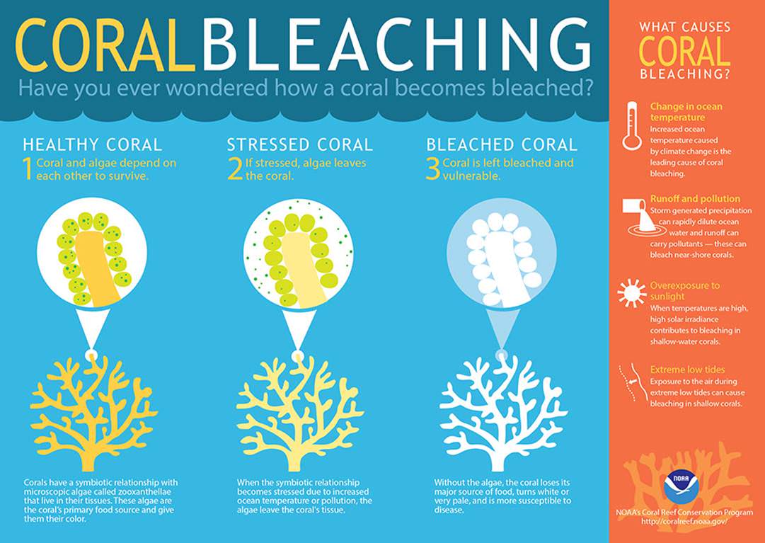

Coral Bleaching
- Disturbances affecting coral reefs include anthropogenic and natural events.
- Recent accelerated coral reef decline is related mostly to anthropogenic impacts (overexploitation, overfishing, increased sedimentation and nutrient overloading).
- Natural disturbances which cause damage to coral reefs include violent storms, flooding, high and low-temperature extremes, El Nino Southern Oscillation (ENSO) events, subaerial exposures, predatory outbreaks and epizootics.
- Coral reef bleaching is a common stress response of corals to many of the various disturbances mentioned above.
- Bleaching occurs when
- the densities of zooxanthellae decline and/or
- the concentration of photosynthetic pigments within the zooxanthellae fall. (it is no more useful for the coral and the coral will bleach it)
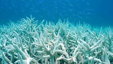

Coral Bleaching
- When corals bleach, they commonly lose 60-90% of their zooxanthellae and each zooxanthellae may lose 50-80% of its photosynthetic pigments.
- If the stress-causing bleaching is not too severe and if it decreases in time, the affected corals usually regain their symbiotic algae within several weeks or a few months.
- If zooxanthellae loss is prolonged, i.e. if the stress continues and depleted zooxanthellae populations do not recover, the coral host eventually dies.
Ecological Causes of Coral Bleaching
Temperature
- Coral species live within a relatively narrow temperature margin, and anomalously low, and high sea temperatures can induce coral bleaching.
- Bleaching events occur during sudden temperature drops accompanying intense upwelling episodes (El-Nino), seasonal cold-air outbreaks.
- While the rising temperatures have increased the frequency and intensity of bleaching, acidification has reduced corals calcifying ability.
- Small temperature increases over many weeks or large increase (3-4 °C) over a few days will result in coral dysfunction.
- Coral bleaching has occurred mostly during the summer seasons or near the end of a protracted warming period.
- They are reported to have taken place during times of low wind velocity, clear skies, calm seas and low turbidity. The conditions favour localised heating and high ultraviolet (UV) radiation.
- UV radiation readily penetrates clear sea waters. The corals actually contain UV-absorbing compounds, but rising temperatures mean reduction in the concentration of these UV absorbing compounds in corals.
Subaerial exposure
- Sudden exposure of corals to the atmosphere during events such as extreme low tides, ENSO-related sea level drops or tectonic uplift can potentially induce bleaching.
- The consequent exposure to high or low temperatures, increased solar radiation, desiccation, and seawater dilution by heavy rains could all play a role in zooxanthellae loss.
Fresh Water Dilution
- Rapid dilution of reef waters from storm-generated precipitation and runoff has been demonstrated to cause coral reef bleaching.
- Generally, such bleaching events are rare and confined to relatively small, near shore areas.
Inorganic Nutrients
- Rather than causing coral reef bleaching, an increase in ambient elemental nutrient concentrations (e.g. ammonia and nitrate) actually increases zooxanthellae densities 2-3 times.
- Although eutrophication (excessive nutrients that results in harmful algal blooms) is not directly involved in zooxanthellae loss, it could cause secondary adverse effects such as lowering of coral resistance and greater susceptibility to diseases.
Xenobiotics
- When corals are exposed to high concentrations of chemical contaminants like copper, herbicides and oil, coral bleaching happens.
Epizootics
- Pathogen induced bleaching is different from other sorts of bleaching.
- Most coral diseases cause patchy or whole colony death and sloughing of soft tissues, resulting in a white skeleton (not to be confused with bleached corals).
Bleaching may also be Beneficial: Recent research has revealed that corals that are consistently exposed to low levels of stress may develop some kind of resistance to bleaching.
Spatial and temporal range of coral reef bleaching
- Nearly all of the world’s major coral reef regions (Caribbean/ western Atlantic, eastern Pacific, central and western Pacific, Indian Ocean, Arabian Gulf, Red Sea) experienced some degree of coral bleaching and mortality during the 1980s.
- Prior to the 1980s, most mass coral moralities were related to non-thermal disturbances such as storms, aerial exposures during extreme low tides, and Acanthaster planci outbreaks (crown-of-thorns seastar, a large starfish that preys upon coral polyps).
Resources from the Ocean
Ocean Deposits
- Ocean deposits are unconsolidated sediments deposited on the ocean floor.
- They are broadly divided into two types —
- the terrigenous deposits (deposits derived from land; found mainly on the continental shelves and slopes), and
- the pelagic deposits (found over deep sea plains and the deeps).
Terrigenous Deposits
- They are mainly inorganic deposits (compounds not containing carbon) derived from disintegrated rock material (due to weathering and water erosion).
- The proportion of organic matter (in the form of shells, corals and skeletons) is quite negligible.
- The disintegrated rock material is carried from land to the sea mainly by running water.
- The terrigenous deposits are found mainly on the continental shelves and slopes.
- Except for fine volcanic ash, little terrigenous material is carried on to the sea surface.
Pelagic Deposits
- Pelagic deposits cover nearly 75% of the total sea floor.
- The pelagic deposits consist of both organic (remains of plants and animals) and inorganic material.
- Organic material is in the form of liquid mud called ooze which contains remnants of shells and skeletons.
- Inorganic material is in the form of red clay which is of volcanic origin.
- The chief constituents of red clay are silicon and aluminium dioxide.
- The red clay is the most widely spread pelagic deposit of the sea floor.
- The red clay covers more than half of the Pacific floor.
Mineral Resources
- Both metallic and non-metallic resources are found in seas.
- Most of these minerals are carried from land to sea by running water.
- The remaining are formed from to undersea volcanism and detritus (leftover parts) of marine organisms.
- At present, mining of only a handful of marine mineral resources is economically viable.
- Among them are offshore oil and natural gas, extraction of sodium chloride, salts of magnesium and bromine, etc.
Mineral deposits found on continental shelves and slopes
- The surface deposits on the continental shelves and slopes are found mixed with sand.
- Sands are mined to extract calcium carbonate along the Bahamas coast.
- Coral sands are mined in Hawaii and Fiji for calcium carbonate.
Marine Placer deposits
- A placer deposit is an accumulation of valuable heavy minerals that have been weathered and eroded from their source rocks.
- As a result of their high density, placer minerals accumulate just a few tens of kilometres away from their source rocks.
- Marine placers deposits accumulate on the continual shelves very close to the shoreline.
- The most economically important of placer minerals are cassiterite (ore of tin), ilmenite (titanium), rutile (titanium), zircon (zirconium), chromite (chromium), monazite (thorium), magnetite (iron), gold and diamonds.
- The beach sands of western India, coastal Brazil, Australia have zircon, monazite (thorium is extracted form monazite sands found across the Kerala coast) and rutile.
- Kerala’s placer deposits contain 90 per cent of the world’s monazite reserves.
- The eastern and western coasts of Australia account for about 30 per cent of rutile.
- Placer diamonds are mainly mined in shelf sediments along the west coast of South Africa and Namibia.
- Gold placers occur along the coast of Alaska on the East Pacific shelf.
- The tin ore, cassiterite, a residue of granite weathering, occurs in the shelf of South East Asia.
Marine hydrocarbon deposits
- Generally, large quantities of hydrocarbons can be formed only at depths within organic-rich layers greater than 1,000 – 2,000 meters.
- Formation of exploitable reservoirs of hydrocarbons requires migration (from their source rocks) to geological traps comprising a porous reservoir rocks and overlain by an impermeable horizon.
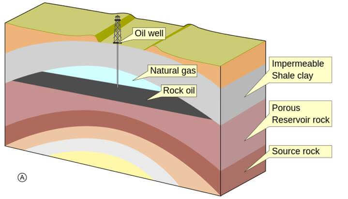

Anticline trap (MagentaGreen, Wikipedia Commons)
- Common geological traps for hydrocarbons include shales, salt domes (evaporites; also rich in sulphur), and anticlinal folds of permeable and non-permeable strata.
- In addition to liquid hydrocarbons, natural gas is also common.
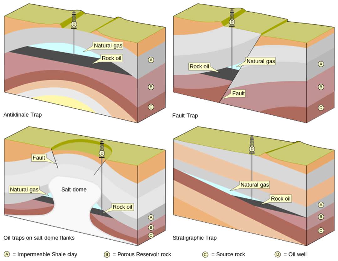

Oil and Gas traps (MagentaGreen, Wikipedia Commons)
- The estimated reserves of oil worldwide at the beginning of the 21st Century are about one trillion barrels.
- Of this amount, about 252 billion barrels (25%) lie in marine environments.
- Similarly, the total worldwide resources of natural gas are estimated at about 4,000 trillion cubic feet, of which about 26 per cent are marine.
- These reserves of oil and gas are located as subsurface deposits almost exclusively on the continental shelves.
- The abyssal plains probably contain insufficient thickness of sediments (less than 1 km) to yield hydrocarbon accumulations.
- Of the twenty-five largest offshore production fields, eight are in the Persian Gulf and eight others are in the North Sea (here hydrocarbons are available at a shallow depth).
- The remaining ones are located in the Gulf of Mexico, East Asia (South China Sea), South Asia, etc.
- The western coast of India has shown promising reserves.
- Besides oil, submerged coal deposits are to be found in the coast of Maharashtra in India.
Challenges in harnessing marine hydrocarbon resources
- The cost of production from deep marine environments is economically unviable considering the present demand.
- Gas and oil exploration increase the risk of marine pollution from accidental oil spills. Existing response technologies are inadequate to contain and recover spills.
Marine phosphorite deposits
- Phosphorites are natural compounds containing phosphate (used in the production of fertilizers).
- They are found in shallow waters and in the form of nodules on the continental shelves and slopes.
- At present, no offshore deposits are being mined because of the availability of non-marine phosphates.
Mineral deposits found on deep sea floor
- The deep sea has two main types of mineral deposits of economic importance: manganese nodules (also called as polymetallic nodules) and metalliferous sediments.
Marine manganese nodules (Polymetallic nodules) and crusts
- Manganese nodules are concentrations of iron and manganese oxides, that can contain economically valuable concentrations of manganese (~30%), nickel (1.25-1.5%), copper (~1%) and cobalt (~0.25%).
- Other constituents include iron (6%), silicon (5%) and aluminium (3%).
- They are thought to have formed from the precipitation of metals from seawater, hot springs associated with volcanic activity and metal hydroxides through the activity of microorganisms.
- Their abundance, composition, and their occurrence as loose material lying on the surface of the seabed make nodules potentially attractive to future mining.
- Manganese-rich crusts, similar in composition to the nodules, occur on rocky outcrops.
- The top ten countries that have the greatest resource potential of nodules and crusts are the United States of America, Madagascar, Brazil, Antarctica, Argentina, Japan, South Africa, Canada and India.
- Papua New Guinea is one of the few places where nodules were located in shallow waters.
- However, the expense of bringing the ore up to the surface proved to be expensive.
Central Indian Ocean Basin (CIOB)
- Manganese nodules in Indian Ocean cover a large area, over 10 million sq. km.
- Large areas in the basins east of the Central Indian Ridge (ridge along the Reunion Hotspot) contains nodules with a high percentage of manganese, nickel and copper.
- India has exclusive rights to explore polymetallic nodules from seabed in Central Indian Ocean Basin (CIOB).
- These rights are over 75000 sq. km of area in international waters allocated by International Seabed Authority for developmental activities for polymetallic nodules.
Challenges
- Difficulty and expense of developing and operating mining technology that could economically remove the nodules from depths of five or six kilometres.
- Continuing availability of the key minerals from land-based sources like nickel at market prices.
- Mining is not economically viable for the next two decades.

Locations of known polymetallic nodules. From World Ocean Review 3, (2014) (Source)

Marine gas hydrate deposits
- Gas hydrate is an icy crystalline compound located at great ocean depths and in shallow polar waters.
- It is composed of gas molecules, normally methane, encaged within water molecules.
- At great ocean depths due to cold temperatures and high ocean pressure gas hydrate remain solid.
- The source of the dissolved gas is from the breakdown of organic matter trapped within marine sediment.
- Hence, gas hydrate deposits are likely to occur everywhere the seafloor exceeds 500 m (or 300 m in high latitudes), and where there is a source of unoxidsed organic carbon in marine sediments.


Gas Hydrate deposits (Source)
- On dissociation at standard atmospheric pressure, gas hydrate yields approximately 164 times its own volume of methane gas.
- Gas hydrates are estimated to hold many times more methane than presently exists in the atmosphere and up to twice the amount of energy of all fossil carbon-based fuels combined.
- Gas hydrates are known from the Atlantic and Pacific margins of both North and South America, especially at equatorial latitudes.


Global gas hydrate deposits
Challenges in economic exploitation of gas hydrate deposits
- Harnessing methane from gas hydrates is extremely challenging as they are stored deep in the ocean.
- Methane hydrates break at higher temperatures and lower pressures, presenting a challenge in the mining.
Methane is a greenhouse gas that traps heat twenty times more proficiently than carbon dioxide
- Gas hydrate reservoirs are extremely sensitive to climate change.
- They can catastrophically accentuate global warming by releasing methane.
- Gas hydrates break into smaller pieces and float upwards.
- Once they hit warmer waters and lower pressures, they break down into methane gas.
- The driving force behind the release of methane gas is the warming of oceans worldwide.
- Mining could unlock excess methane into atmosphere.
Natural gas hydrate in North Indian Ocean
- 2016: ONGC discovered large, highly enriched accumulations of natural gas hydrate in the Bay of Bengal.
- ONGC plans to start pilot production from its discovery from 2017.
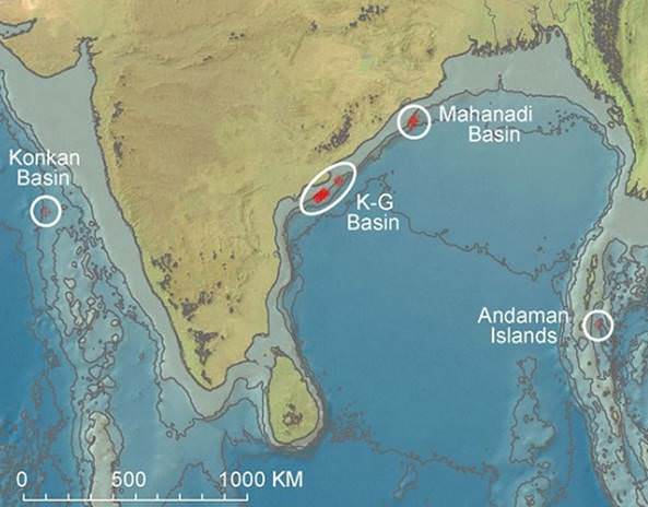

Accumulations of natural gas hydrate in North Indian Ocean


Marine Polymetallic sulphides
- Deep seabed Poly-Metallic Sulphides (PMS) containing iron, copper, zinc, silver, gold, platinum in variable constitutions.
- They are formed due to the precipitation of hot fluids from upwelling hot magma discharged along the mid-ocean ridges.
- Considerable interest has been sparked by the discovery of polymetallic sulphides in Western Indian Ocean.
- India has received a 15 years contract from International Seabed Authority (ISA) for exploration of PMS in the area of 10,000 sq km in parts of Central and South – West Indian Ridges (SWIR).
- In the SWIR, PMS found near the Galapagos rift system contain 48 per cent sulphur, 43 per cent iron, 11 per cent copper and smaller quantities of zinc, tin, molybdenum, lead and silver.
Marine evaporite deposits
- Marine evaporites, formed by evaporation of sea water in geologic basins comprise mainly anhydrite and gypsum (calcium sulphates), sodium and magnesium salts and potash-bearing minerals.
- Rock salt cause upward protrusion forming salt domes, plugs, and other diapiric structures (salt domes explained in Volcanism).
- They can form structures in the sedimentary strata that are favourable for the accumulation of hydrocarbons.
- However, rock salts are abundantly available on land, and there is little value in marine deposits.
Energy Resources
Energy from Tides
- The tides, during rise and fall, release a lot of energy by striking against the shore. This piston action can be used to operate a turbine and produce electricity.
- The USA, the CIS, Japan and France are producing power from tides.
Ocean Thermal Energy Conversion (OTEC)
- In tropical seas, the surface temperature is about 25 °C to 30 °C, while the sub-surface temperature is 5 °C.
- This vertical difference of 25 °C is enough to generate electricity, but it is an expensive option.
- Belgium and Cuba are producing power in this way.
- 2008: An experimental 1MW plant at Kulasekarapattinam in Tamil Nadu was set up.
Geothermal Energy
- This means tapping heat from fracture zones and active volcanoes undersea.
Fresh Water
- Several desalination technologies are in operation, but as yet they are not being used on a large scale, as they are costly.
Technologies adopted in desalinization of sea water
- Electrodialysis employs iron-selective membranes for the desalination of brackish water.
- Flash distillation technique is in use in Saudi Arabia, Kuwait, Island, Pakistan, Chile, and India.
- Reverse osmosis is the most widely used method. Suitable osmotic membranes are used which reject salts and allow water to pass through when sea water is put under high pressure.
Biotic Resources
- At the base of the food chain are the planktons—phytoplankton and zoo-planktons. These are the food for many marine animal species.
- Benthos (sea surface) resources include animals such as crustaceans (prawn, shrimp, crab, lobster) and shellfish or molluscs (mussels, oysters).
- Marine animals provide oil, fur, leather, glue and cattle feed.
- Marine plants and animals are used in curative medicine.
- Seafoods are of high nutritional value.
- Edible fish are of three main types, based on the location of habitat.
- Pelagic fish (mackerel, herring, anchovies, tuna) breed near the surface of seas.
- Demersal fish (haddock, cod, halibut, sole in the temperate region, and snapper and garoupa in tropical waters) feed on or near the sea bed of the continental shelf.
- Then there are the migratory anadromous fish (salmon) that live in the sea but move into fresh water of coastal rivers every year.
- Whales are mammals of the ocean and have been caught not only for food but for industrial and medicinal purposes as well.
Algae
- Algae such as sea lettuces are used in soups and salads and as flavouring.
- Kelp can be cultivated for producing methane gas and used as an energy source by bioconversion
- Brown algae produce algin.
- Algin used as stabilisers in the paints industry, to strengthen ceramics, and to thicken jams.
- Red algae provide agar and carrageenan.
- Agar is an important medium for bacterial culture in research.
- It is also an ingredient in desserts and pharmaceutical products.
- Carrageenan is used as a stabiliser and emulsifier in ice-creams, and in cosmetics and medicines.
United Nations International Conferences on the Law of the Sea (UNCLOS)
- UNCLOS is an international agreement that defines the rights and responsibilities of nations where use of the oceans’ waters by them is concerned.
- UNCLOS deal with aspects like delimitation, control of environmental pollution, commercial activities in the seas, technology transfer and settlement of disputes between States with reference to ocean matters.
- It also creates a legal regime for controlling mineral resource exploitation in deep seabed areas beyond national jurisdiction, through an International Seabed Authority.
- The UNCLOS came into force in the year 1994.
- As of today, it has been signed by more than 150 countries.
- The USA has signed the treaty but has not ratified it.
- The UN provides support for Convention meetings. However, the UN does not have a direct part in the implementation of the Convention.
- But organizations like the International Maritime Organisation and the International Whaling Commission have a role to play.
- UNCLOS uses a consensus process rather than a majority vote to discourage groups of nation-states dominating negotiations.
- Four main decisions have been widely accepted since 1978.
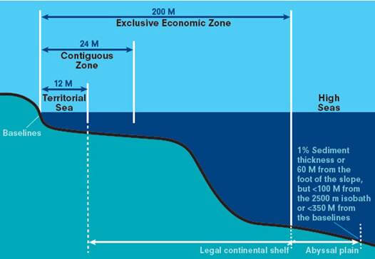

UNCLOS Coastal Zones
Territorial waters
- Territorial waters are those waters over which a state has full sovereignty
- Territorial waters extend for 19 km (12 miles) from the coast.
- Territorial waters include fjords, estuaries and land between the mainland and offshore islands in the internal waters.
Contiguous Zone or Pursuit Zone
- A further contiguous zone of 19 km is recognized in which the coastal state can act against those who break the law (smugglers, pirates, illegal immigrants etc.) within the true territorial waters.
- This, in other words, is a pursuit zone.
Exclusive Economic Zone (EEZ)
- Exclusive economic zone (EEZ) starts at the same baseline as the territorial waters.
- EEZ extend for 320-km (200-mile) from the baseline.
- Within the EEZ the coastal state has the right to exploit all economic resources — fish, minerals, oil and gas and energy production.
- The state may extend these rights to the edge of the shelf — as much as 1280 km (800 miles) in some cases — though this does not include rights to the sea itself beyond the 320 km EEZ.
- Land-locked and geographically disadvantaged states can participate on an equitable basis in exploiting an appropriate part of the surplus of the living resources of the EEZs of coastal states.
- In the EEZ and on the continental shelf, all marine scientific research is subject to relevant coastal State’s consent. The coastal states, in turn, are expected to grant consent for peaceful purposes to other States.
High Seas
- Beyond all the zones in which individual countries can claim control are the high seas.
- The high seas are free for navigation by vessels of all nations.
- The oceans may also be used freely for the laying of submarine cables, and the airspace over them is also free.
- The oceans may also be freely fished by all nations, though some international agreements seek to control overfishing, which endangers some species.
- The States must share with the international community part of the revenue derived from exploiting resources on the continental shelf extending beyond 200 miles.
- Special protection should be accorded to highly migratory species of fish and sea mammals.
Land Disputes in South China Sea: Parcel Islands and Spratly Islands
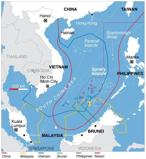

Parcel Islands and Spratly Islands in South China Sea (Voice of America, Wikipedia)
- The Spratly Islands and Paracel Islands are two of the most contested areas in the South China Sea.
- However, unlike other parts of the South China Sea, these areas do not hold large resources of oil and natural gas.
- Most fields containing discovered oil and natural gas are clustered in uncontested parts of the South China Sea, close to shorelines of the coastal countries.
- The Paracel Islands, however, contain significant natural gas hydrate resources.
- Under the UNCLOS, ownership of habitable islands can, however, extend the exclusive access of a country to surrounding energy resources (200 mile EEZ).
- Hence, the country that wins the dispute would have the right to explore and develop whatever the resources that are available in the EEZ.


Oil and Gas reserves around Spratly Islands and Parcel Islands (Source)
Economic and Strategic importance of South China Sea
- 10% of world’s fisheries.
- 30% of global shipping trade.
- Population is 2.2 billion in the region.
- 11 billion barrels of oil.
- 190 trillion cubic feet of natural gas.